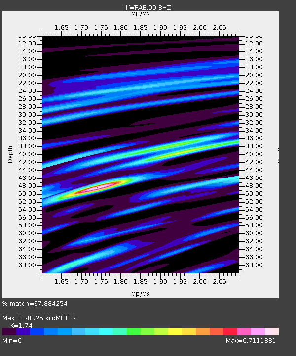
WRAB Tennant Creek, NT, Australia - Earthquake Result Viewer

Earthquake location: Near East Coast Of Honshu, Japan
Earthquake latitude/longitude: 38.3/141.6
Earthquake time(UTC): 2011/04/07 (097) 14:32:43 GMT
Earthquake Depth: 42 km
Earthquake Magnitude: 6.9 MB, 7.0 MS, 7.1 MW, 7.1 MW
Earthquake Catalog/Contributor: WHDF/NEIC
Network: II Global Seismograph Network (GSN - IRIS/IDA)
Station: WRAB Tennant Creek, NT, Australia
Lat/Lon: 19.93 S/134.36 E
Elevation: 366 m
Distance: 58.3 deg
Az: 187.998 deg
Baz: 6.684 deg
Ray Param: 0.06284938
Estimated Moho Depth: 48.25 km
Estimated Crust Vp/Vs: 1.74
Assumed Crust Vp: 6.642 km/s
Estimated Crust Vs: 3.817 km/s
Estimated Crust Poisson's Ratio: 0.25
Radial Match: 97.884254 %
Radial Bump: 314
Transverse Match: 85.96588 %
Transverse Bump: 400
SOD ConfigId: 558545
Insert Time: 2013-09-18 15:42:53.471 +0000
GWidth: 2.5
Max Bumps: 400
Tol: 0.001

Signal To Noise

ChannelStoNSTALTA
II:WRAB:00:BHZ:20110407T14:42:03.169028Z40.617271.3226473E-53.2563665E-7
II:WRAB:00:BH1:20110407T14:42:03.169028Z37.024477.1949603E-61.9432987E-7
II:WRAB:00:BH2:20110407T14:42:03.169028Z6.55613471.4377804E-62.1930308E-7
Arrivals
Ps5.7 SECOND
PpPs19 SECOND
PsPs/PpSs25 SECOND