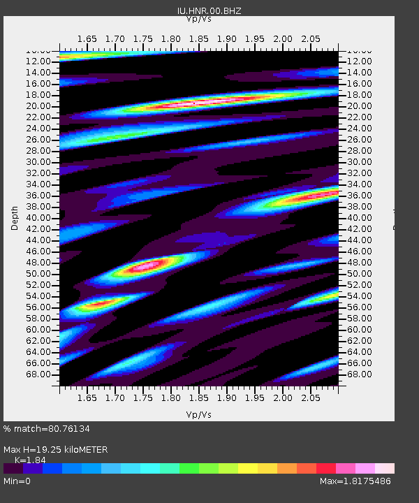
HNR Honiara, Solomon Islands - Earthquake Result Viewer
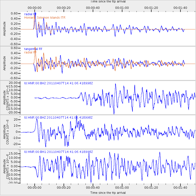
Earthquake location: Near East Coast Of Honshu, Japan
Earthquake latitude/longitude: 38.3/141.6
Earthquake time(UTC): 2011/04/07 (097) 14:32:43 GMT
Earthquake Depth: 42 km
Earthquake Magnitude: 6.9 MB, 7.0 MS, 7.1 MW, 7.1 MW
Earthquake Catalog/Contributor: WHDF/NEIC
Network: IU Global Seismograph Network (GSN - IRIS/USGS)
Station: HNR Honiara, Solomon Islands
Lat/Lon: 9.44 S/159.95 E
Elevation: 100 m
Distance: 50.5 deg
Az: 156.238 deg
Baz: 341.251 deg
Ray Param: 0.067937344
Estimated Moho Depth: 19.25 km
Estimated Crust Vp/Vs: 1.84
Assumed Crust Vp: 6.183 km/s
Estimated Crust Vs: 3.36 km/s
Estimated Crust Poisson's Ratio: 0.29
Radial Match: 80.76134 %
Radial Bump: 400
Transverse Match: 79.59826 %
Transverse Bump: 400
SOD ConfigId: 558545
Insert Time: 2013-09-18 15:43:27.104 +0000
GWidth: 2.5
Max Bumps: 400
Tol: 0.001

Signal To Noise

ChannelStoNSTALTA
IU:HNR:00:BHZ:20110407T14:41:06.418998Z37.371041.1910283E-53.1870357E-7
IU:HNR:00:BH1:20110407T14:41:06.418998Z19.2932177.731042E-64.00713E-7
IU:HNR:00:BH2:20110407T14:41:06.418998Z8.4262113.913949E-64.6449694E-7
Arrivals
Ps2.8 SECOND
PpPs8.4 SECOND
PsPs/PpSs11 SECOND