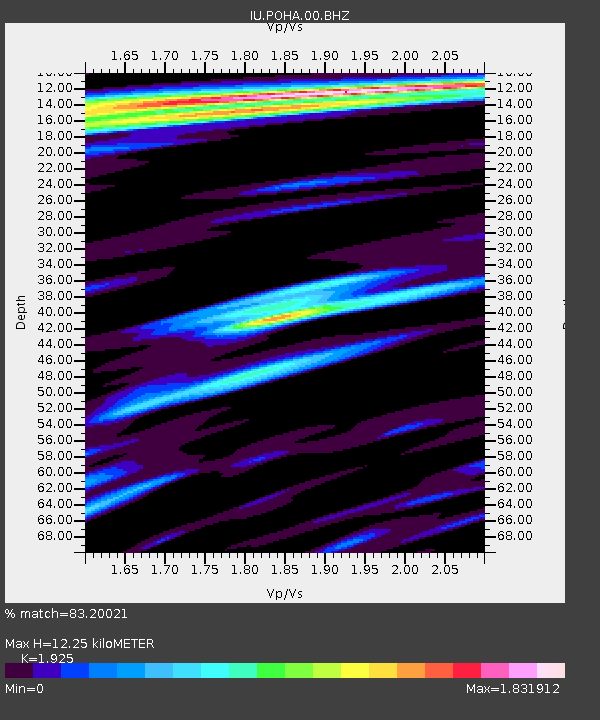
POHA Pohakuloa, Hawaii, USA - Earthquake Result Viewer

Earthquake location: Near East Coast Of Honshu, Japan
Earthquake latitude/longitude: 38.3/141.6
Earthquake time(UTC): 2011/04/07 (097) 14:32:43 GMT
Earthquake Depth: 42 km
Earthquake Magnitude: 6.9 MB, 7.0 MS, 7.1 MW, 7.1 MW
Earthquake Catalog/Contributor: WHDF/NEIC
Network: IU Global Seismograph Network (GSN - IRIS/USGS)
Station: POHA Pohakuloa, Hawaii, USA
Lat/Lon: 19.76 N/155.53 W
Elevation: 1990 m
Distance: 57.0 deg
Az: 90.027 deg
Baz: 303.317 deg
Ray Param: 0.06371003
Estimated Moho Depth: 12.25 km
Estimated Crust Vp/Vs: 1.92
Assumed Crust Vp: 5.195 km/s
Estimated Crust Vs: 2.699 km/s
Estimated Crust Poisson's Ratio: 0.32
Radial Match: 83.20021 %
Radial Bump: 400
Transverse Match: 60.044422 %
Transverse Bump: 400
SOD ConfigId: 558545
Insert Time: 2013-09-18 15:43:52.461 +0000
GWidth: 2.5
Max Bumps: 400
Tol: 0.001

Signal To Noise

ChannelStoNSTALTA
IU:POHA:00:BHZ:20110407T14:41:53.769004Z4.97570669.16588E-61.8421265E-6
IU:POHA:00:BH1:20110407T14:41:53.769004Z2.59386926.578343E-62.5361119E-6
IU:POHA:00:BH2:20110407T14:41:53.769004Z1.28929274.4760936E-63.4717436E-6
Arrivals
Ps2.2 SECOND
PpPs6.7 SECOND
PsPs/PpSs8.9 SECOND