You are here: Home > Network List > US - United States National Seismic Network Stations List
> Station ECSD EROS Data Center, Sioux Falls, South Dakota, USA > Earthquake Result Viewer
ECSD EROS Data Center, Sioux Falls, South Dakota, USA - Earthquake Result Viewer
| Earthquake location: |
Near East Coast Of Honshu, Japan |
| Earthquake latitude/longitude: |
38.3/141.6 |
| Earthquake time(UTC): |
2011/04/07 (097) 14:32:43 GMT |
| Earthquake Depth: |
42 km |
| Earthquake Magnitude: |
6.9 MB, 7.0 MS, 7.1 MW, 7.1 MW |
| Earthquake Catalog/Contributor: |
WHDF/NEIC |
|
| Network: |
US United States National Seismic Network |
| Station: |
ECSD EROS Data Center, Sioux Falls, South Dakota, USA |
| Lat/Lon: |
43.73 N/96.60 W |
| Elevation: |
469 m |
|
| Distance: |
82.9 deg |
| Az: |
38.377 deg |
| Baz: |
317.62 deg |
| Ray Param: |
0.04652375 |
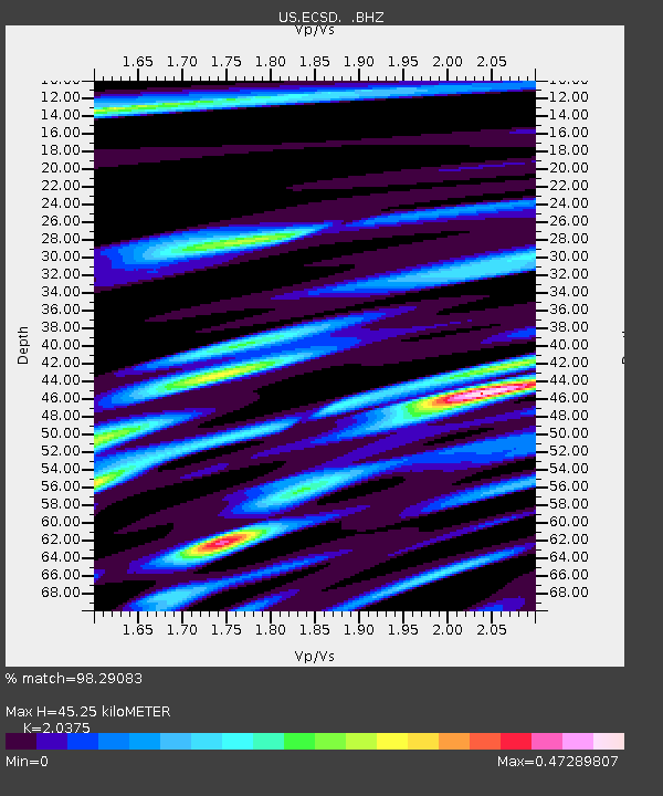
| Estimated Moho Depth: |
45.25 km |
| Estimated Crust Vp/Vs: |
2.04 |
| Assumed Crust Vp: |
6.498 km/s |
| Estimated Crust Vs: |
3.189 km/s |
| Estimated Crust Poisson's Ratio: |
0.34 |
|
| Radial Match: |
98.29083 % |
| Radial Bump: |
290 |
| Transverse Match: |
84.0531 % |
| Transverse Bump: |
400 |
| SOD ConfigId: |
558545 |
| Insert Time: |
2013-09-18 15:44:30.171 +0000 |
| GWidth: |
2.5 |
| Max Bumps: |
400 |
| Tol: |
0.001 |
|

Signal To Noise
| Channel | StoN | STA | LTA |
| US:ECSD: :BHZ:20110407T14:44:32.224021Z | 19.272766 | 6.976725E-6 | 3.6199918E-7 |
| US:ECSD: :BH1:20110407T14:44:32.224021Z | 3.833109 | 1.1428946E-6 | 2.9816385E-7 |
| US:ECSD: :BH2:20110407T14:44:32.224021Z | 12.972593 | 2.42142E-6 | 1.8665659E-7 |
| Arrivals |
| Ps | 7.4 SECOND |
| PpPs | 21 SECOND |
| PsPs/PpSs | 28 SECOND |


