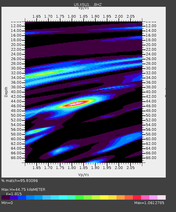
KSU1 Kansas State University--Konza Prairie, Kansas, USA - Earthquake Result Viewer

Earthquake location: Near East Coast Of Honshu, Japan
Earthquake latitude/longitude: 38.3/141.6
Earthquake time(UTC): 2011/04/07 (097) 14:32:43 GMT
Earthquake Depth: 42 km
Earthquake Magnitude: 6.9 MB, 7.0 MS, 7.1 MW, 7.1 MW
Earthquake Catalog/Contributor: WHDF/NEIC
Network: US United States National Seismic Network
Station: KSU1 Kansas State University--Konza Prairie, Kansas, USA
Lat/Lon: 39.10 N/96.61 W
Elevation: 347 m
Distance: 86.3 deg
Az: 41.504 deg
Baz: 317.91 deg
Ray Param: 0.04409581
Estimated Moho Depth: 44.75 km
Estimated Crust Vp/Vs: 1.82
Assumed Crust Vp: 6.483 km/s
Estimated Crust Vs: 3.572 km/s
Estimated Crust Poisson's Ratio: 0.28
Radial Match: 95.93096 %
Radial Bump: 400
Transverse Match: 89.93563 %
Transverse Bump: 400
SOD ConfigId: 558545
Insert Time: 2013-09-18 15:44:43.036 +0000
GWidth: 2.5
Max Bumps: 400
Tol: 0.001

Signal To Noise

ChannelStoNSTALTA
US:KSU1: :BHZ:20110407T14:44:49.500022Z16.925496.1996134E-63.6628856E-7
US:KSU1: :BH1:20110407T14:44:49.500022Z4.0364531.0713155E-62.6541016E-7
US:KSU1: :BH2:20110407T14:44:49.500022Z9.1165592.0004034E-62.1942527E-7
Arrivals
Ps5.8 SECOND
PpPs19 SECOND
PsPs/PpSs25 SECOND