You are here: Home > Network List > II - Global Seismograph Network (GSN - IRIS/IDA) Stations List
> Station PFO Pinon Flat, California, USA > Earthquake Result Viewer
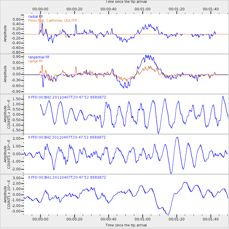
PFO Pinon Flat, California, USA - Earthquake Result Viewer
*The percent match for this event was below the threshold and hence no stack was calculated.
| Earthquake location: |
North Of Honduras |
| Earthquake latitude/longitude: |
17.1/-85.1 |
| Earthquake time(UTC): |
2011/04/07 (097) 20:41:51 GMT |
| Earthquake Depth: |
7.0 km |
| Earthquake Magnitude: |
5.8 MW, 5.9 MW |
| Earthquake Catalog/Contributor: |
NEIC PDE/NEIC PDE-M |
|
| Network: |
II Global Seismograph Network (GSN - IRIS/IDA) |
| Station: |
PFO Pinon Flat, California, USA |
| Lat/Lon: |
33.61 N/116.46 W |
| Elevation: |
1280 m |
|
| Distance: |
32.6 deg |
| Az: |
306.25 deg |
| Baz: |
112.462 deg |
| Ray Param: |
$rayparam |
*The percent match for this event was below the threshold and hence was not used in the summary stack. |
|
| Radial Match: |
67.1557 % |
| Radial Bump: |
400 |
| Transverse Match: |
49.93218 % |
| Transverse Bump: |
400 |
| SOD ConfigId: |
558545 |
| Insert Time: |
2013-09-18 15:44:58.615 +0000 |
| GWidth: |
2.5 |
| Max Bumps: |
400 |
| Tol: |
0.001 |
|
Signal To Noise
| Channel | StoN | STA | LTA |
| II:PFO:00:BHZ:20110407T20:47:52.868987Z | 0.9128848 | 6.8842274E-7 | 7.541179E-7 |
| II:PFO:00:BH1:20110407T20:47:52.868987Z | 1.3320541 | 1.2582701E-6 | 9.4460887E-7 |
| II:PFO:00:BH2:20110407T20:47:52.868987Z | 0.69096637 | 4.2774286E-7 | 6.190502E-7 |
| Arrivals |
| Ps | |
| PpPs | |
| PsPs/PpSs | |


