You are here: Home > Network List > IU - Global Seismograph Network (GSN - IRIS/USGS) Stations List
> Station GNI Garni, Armenia > Earthquake Result Viewer
GNI Garni, Armenia - Earthquake Result Viewer
| Earthquake location: |
Kyushu, Japan |
| Earthquake latitude/longitude: |
30.0/131.8 |
| Earthquake time(UTC): |
2011/04/09 (099) 12:57:48 GMT |
| Earthquake Depth: |
17 km |
| Earthquake Magnitude: |
6.1 MB, 5.6 MS, 6.0 MW, 6.0 MW |
| Earthquake Catalog/Contributor: |
WHDF/NEIC |
|
| Network: |
IU Global Seismograph Network (GSN - IRIS/USGS) |
| Station: |
GNI Garni, Armenia |
| Lat/Lon: |
40.15 N/44.74 E |
| Elevation: |
1609 m |
|
| Distance: |
69.3 deg |
| Az: |
305.072 deg |
| Baz: |
67.853 deg |
| Ray Param: |
0.055738527 |
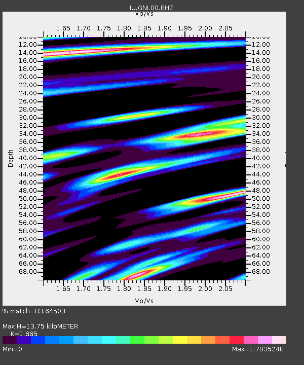
| Estimated Moho Depth: |
13.75 km |
| Estimated Crust Vp/Vs: |
1.66 |
| Assumed Crust Vp: |
6.291 km/s |
| Estimated Crust Vs: |
3.778 km/s |
| Estimated Crust Poisson's Ratio: |
0.22 |
|
| Radial Match: |
83.64503 % |
| Radial Bump: |
400 |
| Transverse Match: |
83.91627 % |
| Transverse Bump: |
400 |
| SOD ConfigId: |
558545 |
| Insert Time: |
2013-09-18 15:46:58.304 +0000 |
| GWidth: |
2.5 |
| Max Bumps: |
400 |
| Tol: |
0.001 |
|
Signal To Noise
| Channel | StoN | STA | LTA |
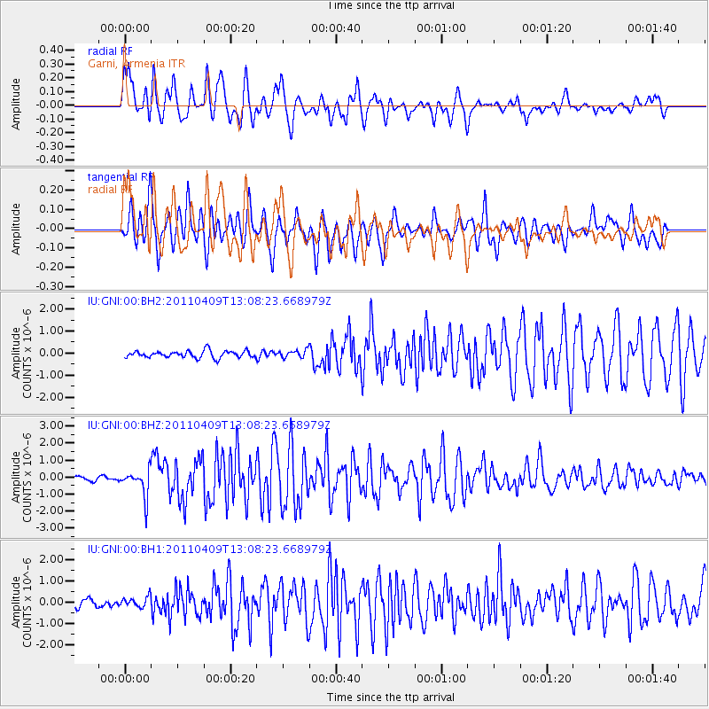
| IU:GNI:00:BHZ:20110409T13:08:23.668979Z | 6.6960797 | 8.042241E-7 | 1.2010372E-7 |
| IU:GNI:00:BH1:20110409T13:08:23.668979Z | 1.5251836 | 2.4339212E-7 | 1.5958219E-7 |
| IU:GNI:00:BH2:20110409T13:08:23.668979Z | 1.1149117 | 1.76669E-7 | 1.5846008E-7 |
| Arrivals |
| Ps | 1.5 SECOND |
| PpPs | 5.6 SECOND |
| PsPs/PpSs | 7.1 SECOND |


