You are here: Home > Network List > II - Global Seismograph Network (GSN - IRIS/IDA) Stations List
> Station WRAB Tennant Creek, NT, Australia > Earthquake Result Viewer
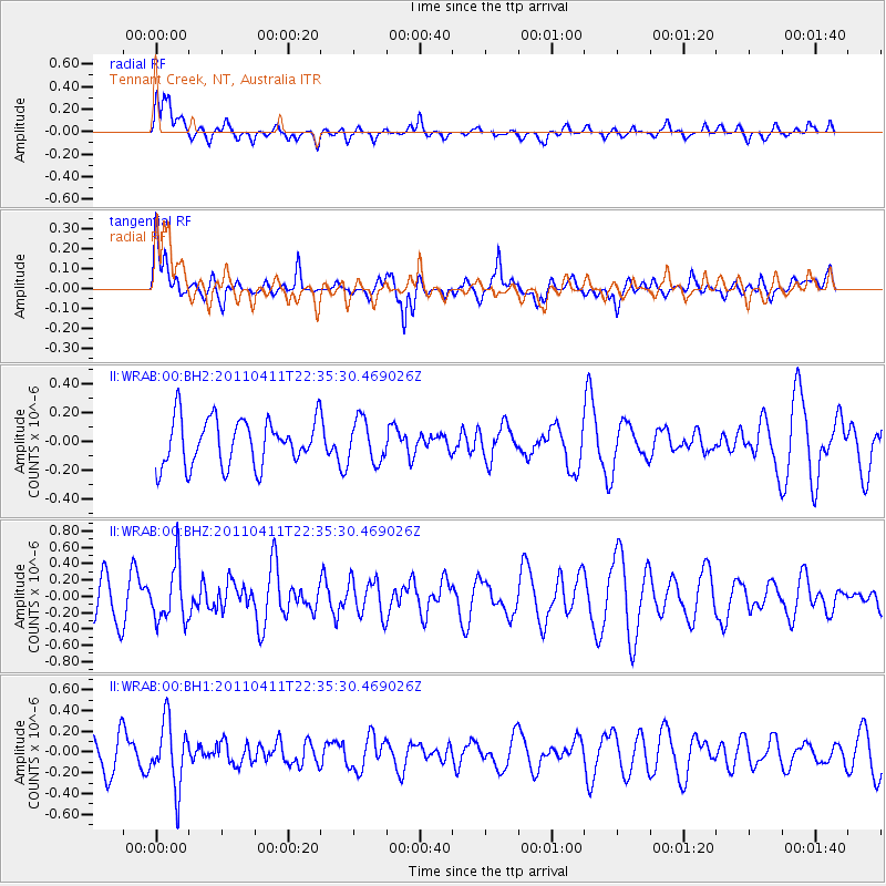
WRAB Tennant Creek, NT, Australia - Earthquake Result Viewer
*The percent match for this event was below the threshold and hence no stack was calculated.
| Earthquake location: |
Eastern Honshu, Japan |
| Earthquake latitude/longitude: |
36.8/138.3 |
| Earthquake time(UTC): |
2011/04/11 (101) 22:26:20 GMT |
| Earthquake Depth: |
17 km |
| Earthquake Magnitude: |
5.5 MW |
| Earthquake Catalog/Contributor: |
NEIC PDE/NEIC PDE-M |
|
| Network: |
II Global Seismograph Network (GSN - IRIS/IDA) |
| Station: |
WRAB Tennant Creek, NT, Australia |
| Lat/Lon: |
19.93 S/134.36 E |
| Elevation: |
366 m |
|
| Distance: |
56.6 deg |
| Az: |
184.425 deg |
| Baz: |
3.774 deg |
| Ray Param: |
$rayparam |
*The percent match for this event was below the threshold and hence was not used in the summary stack. |
|
| Radial Match: |
58.50431 % |
| Radial Bump: |
400 |
| Transverse Match: |
68.75195 % |
| Transverse Bump: |
400 |
| SOD ConfigId: |
558545 |
| Insert Time: |
2013-09-18 15:55:55.929 +0000 |
| GWidth: |
2.5 |
| Max Bumps: |
400 |
| Tol: |
0.001 |
|
Signal To Noise
| Channel | StoN | STA | LTA |
| II:WRAB:00:BHZ:20110411T22:35:30.469026Z | 1.3401743 | 3.400444E-7 | 2.5373149E-7 |
| II:WRAB:00:BH1:20110411T22:35:30.469026Z | 2.0485063 | 3.098316E-7 | 1.5124758E-7 |
| II:WRAB:00:BH2:20110411T22:35:30.469026Z | 0.897561 | 1.4476747E-7 | 1.6128983E-7 |
| Arrivals |
| Ps | |
| PpPs | |
| PsPs/PpSs | |


