You are here: Home > Network List > IU - Global Seismograph Network (GSN - IRIS/USGS) Stations List
> Station POHA Pohakuloa, Hawaii, USA > Earthquake Result Viewer
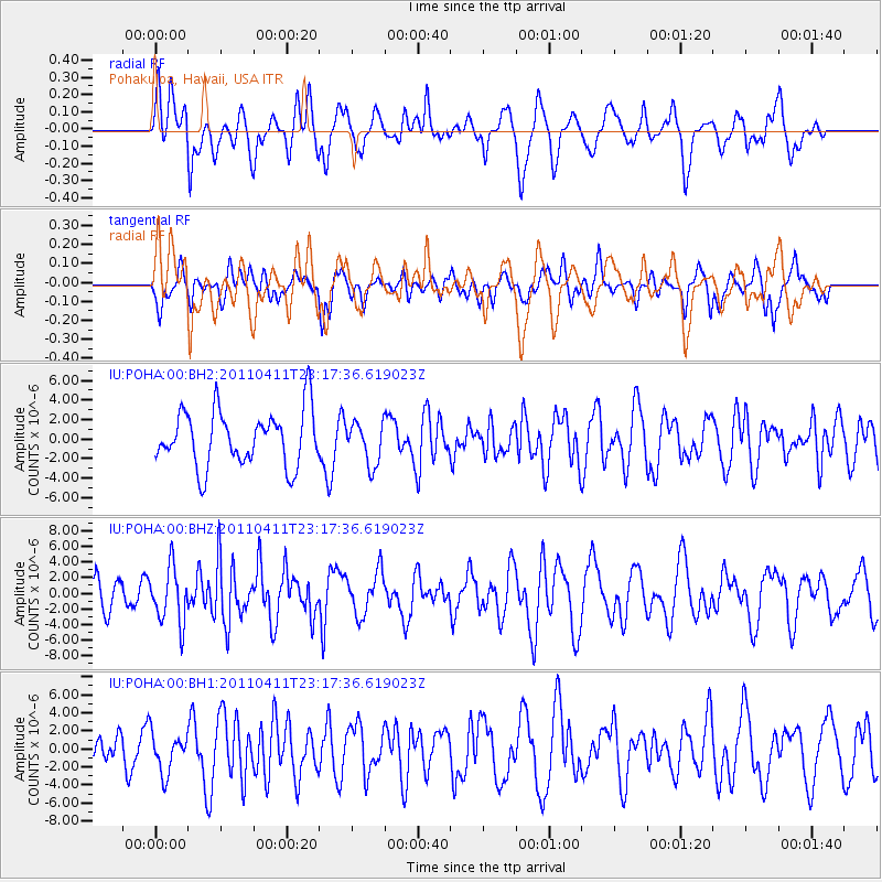
POHA Pohakuloa, Hawaii, USA - Earthquake Result Viewer
*The percent match for this event was below the threshold and hence no stack was calculated.
| Earthquake location: |
Near East Coast Of Honshu, Japan |
| Earthquake latitude/longitude: |
35.4/140.6 |
| Earthquake time(UTC): |
2011/04/11 (101) 23:08:16 GMT |
| Earthquake Depth: |
15 km |
| Earthquake Magnitude: |
6.0 MB, 6.1 MS, 6.2 MW, 6.2 MW |
| Earthquake Catalog/Contributor: |
WHDF/NEIC |
|
| Network: |
IU Global Seismograph Network (GSN - IRIS/USGS) |
| Station: |
POHA Pohakuloa, Hawaii, USA |
| Lat/Lon: |
19.76 N/155.53 W |
| Elevation: |
1990 m |
|
| Distance: |
57.8 deg |
| Az: |
87.607 deg |
| Baz: |
299.95 deg |
| Ray Param: |
$rayparam |
*The percent match for this event was below the threshold and hence was not used in the summary stack. |
|
| Radial Match: |
63.260353 % |
| Radial Bump: |
400 |
| Transverse Match: |
51.943924 % |
| Transverse Bump: |
363 |
| SOD ConfigId: |
558545 |
| Insert Time: |
2013-09-18 15:58:00.603 +0000 |
| GWidth: |
2.5 |
| Max Bumps: |
400 |
| Tol: |
0.001 |
|
Signal To Noise
| Channel | StoN | STA | LTA |
| IU:POHA:00:BHZ:20110411T23:17:36.619023Z | 1.9212395 | 3.5623661E-6 | 1.854202E-6 |
| IU:POHA:00:BH1:20110411T23:17:36.619023Z | 1.0290332 | 2.1702506E-6 | 2.109019E-6 |
| IU:POHA:00:BH2:20110411T23:17:36.619023Z | 0.7604208 | 2.1625785E-6 | 2.8439233E-6 |
| Arrivals |
| Ps | |
| PpPs | |
| PsPs/PpSs | |


