You are here: Home > Network List > KZ - Kazakhstan Network Stations List
> Station KUR21 Cross-array, Kurchatov, Kazakstan > Earthquake Result Viewer
KUR21 Cross-array, Kurchatov, Kazakstan - Earthquake Result Viewer
| Earthquake location: |
Eastern Honshu, Japan |
| Earthquake latitude/longitude: |
37.1/140.4 |
| Earthquake time(UTC): |
2011/04/12 (102) 05:07:41 GMT |
| Earthquake Depth: |
11 km |
| Earthquake Magnitude: |
6.3 MB, 5.7 MS, 6.0 MW, 5.9 MW |
| Earthquake Catalog/Contributor: |
WHDF/NEIC |
|
| Network: |
KZ Kazakhstan Network |
| Station: |
KUR21 Cross-array, Kurchatov, Kazakstan |
| Lat/Lon: |
50.62 N/78.53 E |
| Elevation: |
200 m |
|
| Distance: |
45.3 deg |
| Az: |
307.806 deg |
| Baz: |
82.581 deg |
| Ray Param: |
0.07136893 |
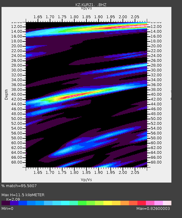
| Estimated Moho Depth: |
11.5 km |
| Estimated Crust Vp/Vs: |
2.09 |
| Assumed Crust Vp: |
6.552 km/s |
| Estimated Crust Vs: |
3.135 km/s |
| Estimated Crust Poisson's Ratio: |
0.35 |
|
| Radial Match: |
95.5807 % |
| Radial Bump: |
400 |
| Transverse Match: |
95.61734 % |
| Transverse Bump: |
351 |
| SOD ConfigId: |
558545 |
| Insert Time: |
2013-09-18 16:00:45.129 +0000 |
| GWidth: |
2.5 |
| Max Bumps: |
400 |
| Tol: |
0.001 |
|

Signal To Noise
| Channel | StoN | STA | LTA |
| KZ:KUR21: :BHZ:20110412T05:15:28.625015Z | 38.611526 | 1.8264825E-6 | 4.7304074E-8 |
| KZ:KUR21: :BH1:20110412T05:15:28.625015Z | 19.823704 | 9.257684E-7 | 4.6700073E-8 |
| KZ:KUR21: :BH2:20110412T05:15:28.625015Z | 3.8091729 | 1.6256323E-7 | 4.2676778E-8 |
| Arrivals |
| Ps | 2.0 SECOND |
| PpPs | 5.1 SECOND |
| PsPs/PpSs | 7.2 SECOND |


