You are here: Home > Network List > CN - Canadian National Seismograph Network Stations List
> Station FRB IQALUIT, N.W.T. > Earthquake Result Viewer
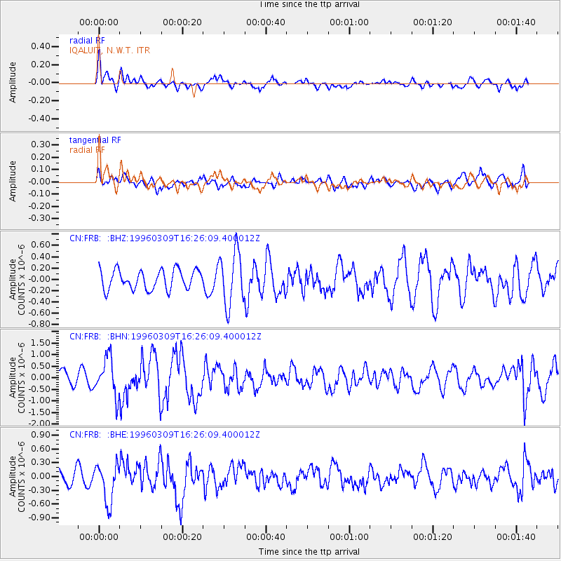
FRB IQALUIT, N.W.T. - Earthquake Result Viewer
*The percent match for this event was below the threshold and hence no stack was calculated.
| Earthquake location: |
East Of Kuril Islands |
| Earthquake latitude/longitude: |
43.4/148.0 |
| Earthquake time(UTC): |
1996/03/09 (069) 16:15:36 GMT |
| Earthquake Depth: |
33 km |
| Earthquake Magnitude: |
5.6 MB, 5.9 MS, 6.1 UNKNOWN, 5.5 MS |
| Earthquake Catalog/Contributor: |
WHDF/NEIC |
|
| Network: |
CN Canadian National Seismograph Network |
| Station: |
FRB IQALUIT, N.W.T. |
| Lat/Lon: |
63.75 N/68.55 W |
| Elevation: |
18 m |
|
| Distance: |
69.3 deg |
| Az: |
16.447 deg |
| Baz: |
332.365 deg |
| Ray Param: |
$rayparam |
*The percent match for this event was below the threshold and hence was not used in the summary stack. |
|
| Radial Match: |
74.36143 % |
| Radial Bump: |
400 |
| Transverse Match: |
51.925274 % |
| Transverse Bump: |
400 |
| SOD ConfigId: |
4480 |
| Insert Time: |
2010-02-27 05:57:22.985 +0000 |
| GWidth: |
2.5 |
| Max Bumps: |
400 |
| Tol: |
0.001 |
|
Signal To Noise
| Channel | StoN | STA | LTA |
| CN:FRB: :BHN:19960309T16:26:09.400012Z | 3.3904207 | 8.4417957E-7 | 2.4898964E-7 |
| CN:FRB: :BHE:19960309T16:26:09.400012Z | 2.974191 | 4.3277984E-7 | 1.4551179E-7 |
| CN:FRB: :BHZ:19960309T16:26:09.400012Z | 2.805967 | 4.806008E-7 | 1.7127815E-7 |
| Arrivals |
| Ps | |
| PpPs | |
| PsPs/PpSs | |


