You are here: Home > Network List > IU - Global Seismograph Network (GSN - IRIS/USGS) Stations List
> Station RSSD Black Hills, South Dakota, USA > Earthquake Result Viewer
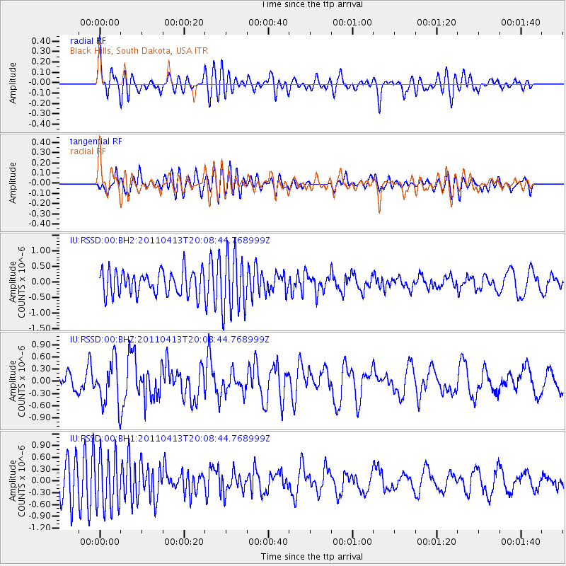
RSSD Black Hills, South Dakota, USA - Earthquake Result Viewer
*The percent match for this event was below the threshold and hence no stack was calculated.
| Earthquake location: |
Off East Coast Of Honshu, Japan |
| Earthquake latitude/longitude: |
39.6/143.3 |
| Earthquake time(UTC): |
2011/04/13 (103) 19:57:25 GMT |
| Earthquake Depth: |
22 km |
| Earthquake Magnitude: |
6.0 MW, 5.8 MB, 6.0 MS, 6.1 MW |
| Earthquake Catalog/Contributor: |
NEIC PDE/NEIC PDE-M |
|
| Network: |
IU Global Seismograph Network (GSN - IRIS/USGS) |
| Station: |
RSSD Black Hills, South Dakota, USA |
| Lat/Lon: |
44.12 N/104.04 W |
| Elevation: |
2090 m |
|
| Distance: |
76.9 deg |
| Az: |
43.037 deg |
| Baz: |
312.92 deg |
| Ray Param: |
$rayparam |
*The percent match for this event was below the threshold and hence was not used in the summary stack. |
|
| Radial Match: |
47.191265 % |
| Radial Bump: |
400 |
| Transverse Match: |
46.843567 % |
| Transverse Bump: |
400 |
| SOD ConfigId: |
558545 |
| Insert Time: |
2013-09-18 16:05:29.702 +0000 |
| GWidth: |
2.5 |
| Max Bumps: |
400 |
| Tol: |
0.001 |
|
Signal To Noise
| Channel | StoN | STA | LTA |
| IU:RSSD:00:BHZ:20110413T20:08:44.768999Z | 2.7496095 | 5.573979E-7 | 2.0271894E-7 |
| IU:RSSD:00:BH1:20110413T20:08:44.768999Z | 1.6150318 | 6.8312676E-7 | 4.2298035E-7 |
| IU:RSSD:00:BH2:20110413T20:08:44.768999Z | 2.470217 | 9.371074E-7 | 3.7936238E-7 |
| Arrivals |
| Ps | |
| PpPs | |
| PsPs/PpSs | |


