You are here: Home > Network List > II - Global Seismograph Network (GSN - IRIS/IDA) Stations List
> Station WRAB Tennant Creek, NT, Australia > Earthquake Result Viewer
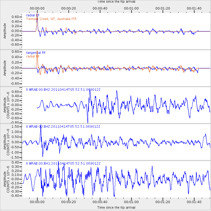
WRAB Tennant Creek, NT, Australia - Earthquake Result Viewer
*The percent match for this event was below the threshold and hence no stack was calculated.
| Earthquake location: |
South Of Kermadec Islands |
| Earthquake latitude/longitude: |
-33.0/-178.5 |
| Earthquake time(UTC): |
2011/04/14 (104) 05:45:17 GMT |
| Earthquake Depth: |
19 km |
| Earthquake Magnitude: |
5.6 MS, 5.4 MB, 5.4 MW |
| Earthquake Catalog/Contributor: |
WHDF/NEIC |
|
| Network: |
II Global Seismograph Network (GSN - IRIS/IDA) |
| Station: |
WRAB Tennant Creek, NT, Australia |
| Lat/Lon: |
19.93 S/134.36 E |
| Elevation: |
366 m |
|
| Distance: |
43.8 deg |
| Az: |
275.212 deg |
| Baz: |
117.25 deg |
| Ray Param: |
$rayparam |
*The percent match for this event was below the threshold and hence was not used in the summary stack. |
|
| Radial Match: |
77.821205 % |
| Radial Bump: |
315 |
| Transverse Match: |
56.565388 % |
| Transverse Bump: |
400 |
| SOD ConfigId: |
558545 |
| Insert Time: |
2013-09-18 16:08:41.322 +0000 |
| GWidth: |
2.5 |
| Max Bumps: |
400 |
| Tol: |
0.001 |
|
Signal To Noise
| Channel | StoN | STA | LTA |
| II:WRAB:00:BHZ:20110414T05:52:51.069012Z | 5.181797 | 6.008458E-7 | 1.1595317E-7 |
| II:WRAB:00:BH1:20110414T05:52:51.069012Z | 1.4645108 | 1.8573246E-7 | 1.2682217E-7 |
| II:WRAB:00:BH2:20110414T05:52:51.069012Z | 3.2760184 | 3.048515E-7 | 9.305549E-8 |
| Arrivals |
| Ps | |
| PpPs | |
| PsPs/PpSs | |


