You are here: Home > Network List > IU - Global Seismograph Network (GSN - IRIS/USGS) Stations List
> Station PMG Port Moresby, New Guinea > Earthquake Result Viewer
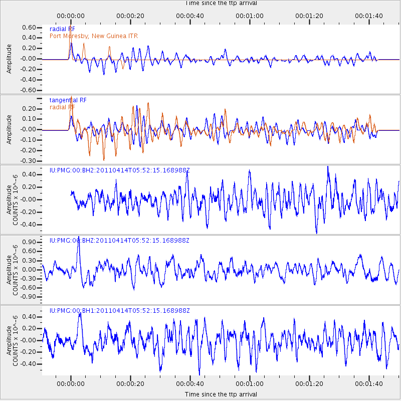
PMG Port Moresby, New Guinea - Earthquake Result Viewer
*The percent match for this event was below the threshold and hence no stack was calculated.
| Earthquake location: |
South Of Kermadec Islands |
| Earthquake latitude/longitude: |
-33.0/-178.5 |
| Earthquake time(UTC): |
2011/04/14 (104) 05:45:17 GMT |
| Earthquake Depth: |
19 km |
| Earthquake Magnitude: |
5.6 MS, 5.4 MB, 5.4 MW |
| Earthquake Catalog/Contributor: |
WHDF/NEIC |
|
| Network: |
IU Global Seismograph Network (GSN - IRIS/USGS) |
| Station: |
PMG Port Moresby, New Guinea |
| Lat/Lon: |
9.40 S/147.16 E |
| Elevation: |
90 m |
|
| Distance: |
39.4 deg |
| Az: |
298.817 deg |
| Baz: |
131.776 deg |
| Ray Param: |
$rayparam |
*The percent match for this event was below the threshold and hence was not used in the summary stack. |
|
| Radial Match: |
58.2247 % |
| Radial Bump: |
400 |
| Transverse Match: |
57.931618 % |
| Transverse Bump: |
400 |
| SOD ConfigId: |
558545 |
| Insert Time: |
2013-09-18 16:09:23.962 +0000 |
| GWidth: |
2.5 |
| Max Bumps: |
400 |
| Tol: |
0.001 |
|
Signal To Noise
| Channel | StoN | STA | LTA |
| IU:PMG:00:BHZ:20110414T05:52:15.168988Z | 2.9375448 | 4.2493136E-7 | 1.4465527E-7 |
| IU:PMG:00:BH1:20110414T05:52:15.168988Z | 1.8194841 | 2.1358677E-7 | 1.17388645E-7 |
| IU:PMG:00:BH2:20110414T05:52:15.168988Z | 1.3236909 | 1.3529164E-7 | 1.02207885E-7 |
| Arrivals |
| Ps | |
| PpPs | |
| PsPs/PpSs | |


