You are here: Home > Network List > IU - Global Seismograph Network (GSN - IRIS/USGS) Stations List
> Station RSSD Black Hills, South Dakota, USA > Earthquake Result Viewer
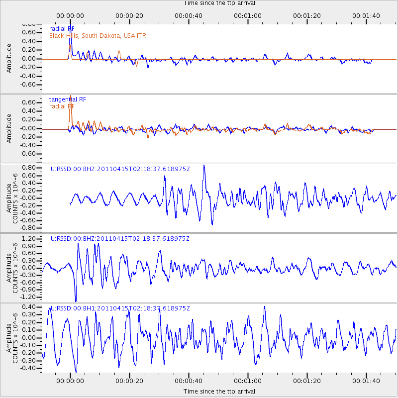
RSSD Black Hills, South Dakota, USA - Earthquake Result Viewer
*The percent match for this event was below the threshold and hence no stack was calculated.
| Earthquake location: |
Tonga Islands |
| Earthquake latitude/longitude: |
-15.3/-173.2 |
| Earthquake time(UTC): |
2011/04/15 (105) 02:06:28 GMT |
| Earthquake Depth: |
17 km |
| Earthquake Magnitude: |
5.8 MW, 5.7 MS, 5.8 MB, 5.8 MW |
| Earthquake Catalog/Contributor: |
NEIC PDE/NEIC PDE-M |
|
| Network: |
IU Global Seismograph Network (GSN - IRIS/USGS) |
| Station: |
RSSD Black Hills, South Dakota, USA |
| Lat/Lon: |
44.12 N/104.04 W |
| Elevation: |
2090 m |
|
| Distance: |
86.3 deg |
| Az: |
42.431 deg |
| Baz: |
244.705 deg |
| Ray Param: |
$rayparam |
*The percent match for this event was below the threshold and hence was not used in the summary stack. |
|
| Radial Match: |
74.040344 % |
| Radial Bump: |
400 |
| Transverse Match: |
66.02191 % |
| Transverse Bump: |
400 |
| SOD ConfigId: |
558545 |
| Insert Time: |
2013-09-18 16:15:01.817 +0000 |
| GWidth: |
2.5 |
| Max Bumps: |
400 |
| Tol: |
0.001 |
|
Signal To Noise
| Channel | StoN | STA | LTA |
| IU:RSSD:00:BHZ:20110415T02:18:37.618975Z | 4.2779264 | 5.559149E-7 | 1.2994961E-7 |
| IU:RSSD:00:BH1:20110415T02:18:37.618975Z | 1.69755 | 2.2244713E-7 | 1.310401E-7 |
| IU:RSSD:00:BH2:20110415T02:18:37.618975Z | 2.3850272 | 2.4745202E-7 | 1.0375228E-7 |
| Arrivals |
| Ps | |
| PpPs | |
| PsPs/PpSs | |


