You are here: Home > Network List > II - Global Seismograph Network (GSN - IRIS/IDA) Stations List
> Station WRAB Tennant Creek, NT, Australia > Earthquake Result Viewer
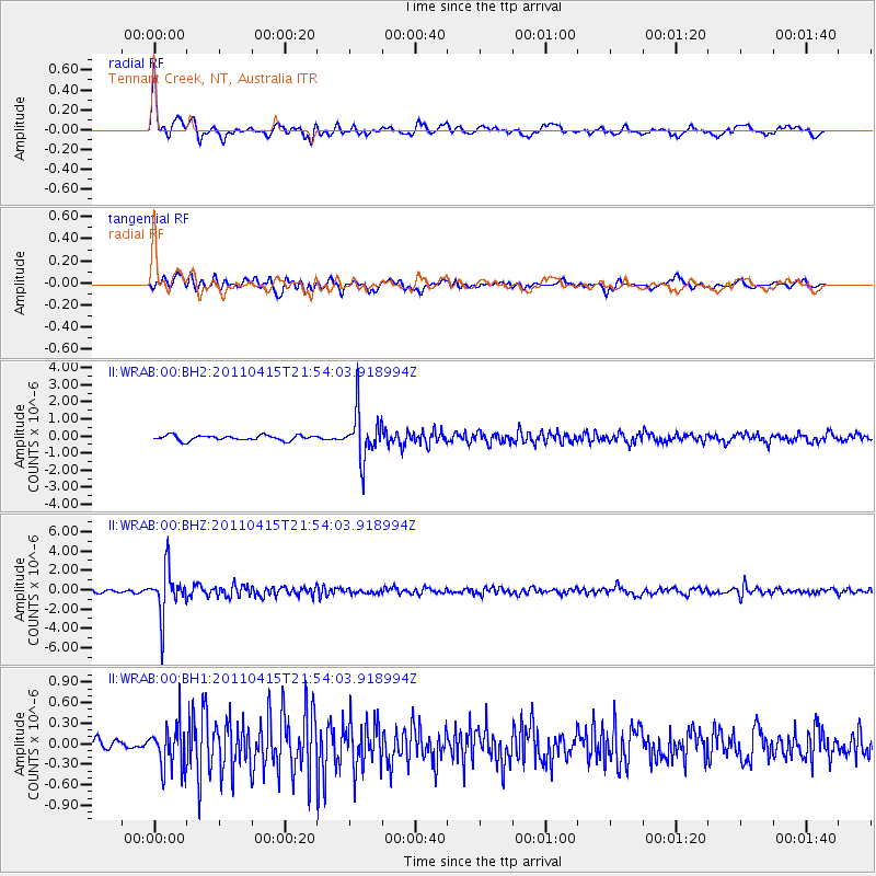
WRAB Tennant Creek, NT, Australia - Earthquake Result Viewer
*The percent match for this event was below the threshold and hence no stack was calculated.
| Earthquake location: |
Tonga Islands |
| Earthquake latitude/longitude: |
-18.7/-175.4 |
| Earthquake time(UTC): |
2011/04/15 (105) 21:46:22 GMT |
| Earthquake Depth: |
216 km |
| Earthquake Magnitude: |
5.7 MW, 5.7 MB, 5.7 MW |
| Earthquake Catalog/Contributor: |
NEIC PDE/NEIC PDE-M |
|
| Network: |
II Global Seismograph Network (GSN - IRIS/IDA) |
| Station: |
WRAB Tennant Creek, NT, Australia |
| Lat/Lon: |
19.93 S/134.36 E |
| Elevation: |
366 m |
|
| Distance: |
47.3 deg |
| Az: |
259.836 deg |
| Baz: |
97.376 deg |
| Ray Param: |
$rayparam |
*The percent match for this event was below the threshold and hence was not used in the summary stack. |
|
| Radial Match: |
79.57814 % |
| Radial Bump: |
399 |
| Transverse Match: |
70.21583 % |
| Transverse Bump: |
400 |
| SOD ConfigId: |
558545 |
| Insert Time: |
2013-09-18 16:16:30.329 +0000 |
| GWidth: |
2.5 |
| Max Bumps: |
400 |
| Tol: |
0.001 |
|
Signal To Noise
| Channel | StoN | STA | LTA |
| II:WRAB:00:BHZ:20110415T21:54:03.918994Z | 19.007421 | 2.404044E-6 | 1.2647922E-7 |
| II:WRAB:00:BH1:20110415T21:54:03.918994Z | 2.9637177 | 3.1620837E-7 | 1.0669316E-7 |
| II:WRAB:00:BH2:20110415T21:54:03.918994Z | 9.334624 | 1.3976941E-6 | 1.4973222E-7 |
| Arrivals |
| Ps | |
| PpPs | |
| PsPs/PpSs | |


