You are here: Home > Network List > II - Global Seismograph Network (GSN - IRIS/IDA) Stations List
> Station PFO Pinon Flat, California, USA > Earthquake Result Viewer
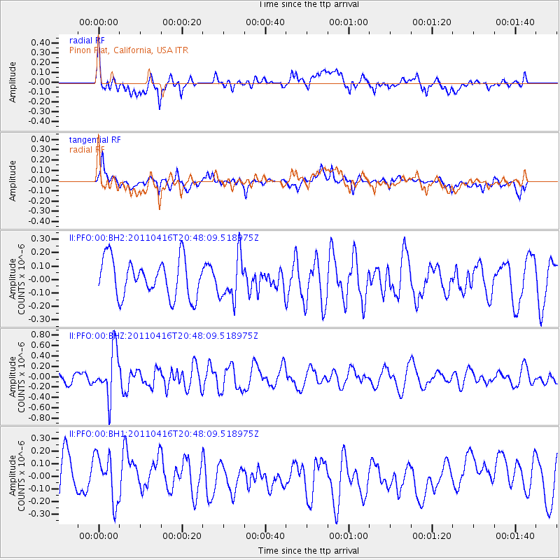
PFO Pinon Flat, California, USA - Earthquake Result Viewer
*The percent match for this event was below the threshold and hence no stack was calculated.
| Earthquake location: |
Off East Coast Of Honshu, Japan |
| Earthquake latitude/longitude: |
36.9/143.9 |
| Earthquake time(UTC): |
2011/04/16 (106) 20:36:46 GMT |
| Earthquake Depth: |
15 km |
| Earthquake Magnitude: |
5.5 MW, 5.5 MW, 5.8 MB |
| Earthquake Catalog/Contributor: |
NEIC PDE/NEIC PDE-M |
|
| Network: |
II Global Seismograph Network (GSN - IRIS/IDA) |
| Station: |
PFO Pinon Flat, California, USA |
| Lat/Lon: |
33.61 N/116.46 W |
| Elevation: |
1280 m |
|
| Distance: |
77.4 deg |
| Az: |
57.449 deg |
| Baz: |
305.913 deg |
| Ray Param: |
$rayparam |
*The percent match for this event was below the threshold and hence was not used in the summary stack. |
|
| Radial Match: |
55.93952 % |
| Radial Bump: |
400 |
| Transverse Match: |
56.196365 % |
| Transverse Bump: |
400 |
| SOD ConfigId: |
558545 |
| Insert Time: |
2013-09-18 16:23:37.497 +0000 |
| GWidth: |
2.5 |
| Max Bumps: |
400 |
| Tol: |
0.001 |
|
Signal To Noise
| Channel | StoN | STA | LTA |
| II:PFO:00:BHZ:20110416T20:48:09.518975Z | 4.6286182 | 4.6712927E-7 | 1.00921966E-7 |
| II:PFO:00:BH1:20110416T20:48:09.518975Z | 1.2487222 | 1.9550198E-7 | 1.5656164E-7 |
| II:PFO:00:BH2:20110416T20:48:09.518975Z | 1.1801463 | 1.6415719E-7 | 1.3909901E-7 |
| Arrivals |
| Ps | |
| PpPs | |
| PsPs/PpSs | |


