You are here: Home > Network List > IU - Global Seismograph Network (GSN - IRIS/USGS) Stations List
> Station MAKZ Makanchi, Kazakhstan > Earthquake Result Viewer
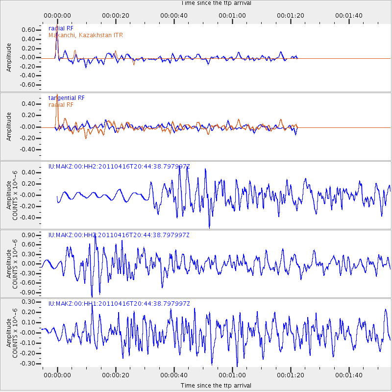
MAKZ Makanchi, Kazakhstan - Earthquake Result Viewer
*The percent match for this event was below the threshold and hence no stack was calculated.
| Earthquake location: |
Off East Coast Of Honshu, Japan |
| Earthquake latitude/longitude: |
36.9/143.9 |
| Earthquake time(UTC): |
2011/04/16 (106) 20:36:46 GMT |
| Earthquake Depth: |
15 km |
| Earthquake Magnitude: |
5.5 MW, 5.5 MW, 5.8 MB |
| Earthquake Catalog/Contributor: |
NEIC PDE/NEIC PDE-M |
|
| Network: |
IU Global Seismograph Network (GSN - IRIS/USGS) |
| Station: |
MAKZ Makanchi, Kazakhstan |
| Lat/Lon: |
46.81 N/81.98 E |
| Elevation: |
600 m |
|
| Distance: |
46.1 deg |
| Az: |
302.737 deg |
| Baz: |
79.096 deg |
| Ray Param: |
$rayparam |
*The percent match for this event was below the threshold and hence was not used in the summary stack. |
|
| Radial Match: |
78.9711 % |
| Radial Bump: |
376 |
| Transverse Match: |
62.114243 % |
| Transverse Bump: |
400 |
| SOD ConfigId: |
558545 |
| Insert Time: |
2013-09-18 16:24:28.701 +0000 |
| GWidth: |
2.5 |
| Max Bumps: |
400 |
| Tol: |
0.001 |
|
Signal To Noise
| Channel | StoN | STA | LTA |
| IU:MAKZ:00:HHZ:20110416T20:44:38.797997Z | 3.8331907 | 2.7767518E-7 | 7.24397E-8 |
| IU:MAKZ:00:HH1:20110416T20:44:38.797997Z | 1.3342055 | 5.6709286E-8 | 4.250416E-8 |
| IU:MAKZ:00:HH2:20110416T20:44:38.797997Z | 2.714733 | 1.4760373E-7 | 5.4371366E-8 |
| Arrivals |
| Ps | |
| PpPs | |
| PsPs/PpSs | |


