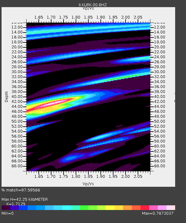
KURK Kurchatov, Kazakhstan - Earthquake Result Viewer
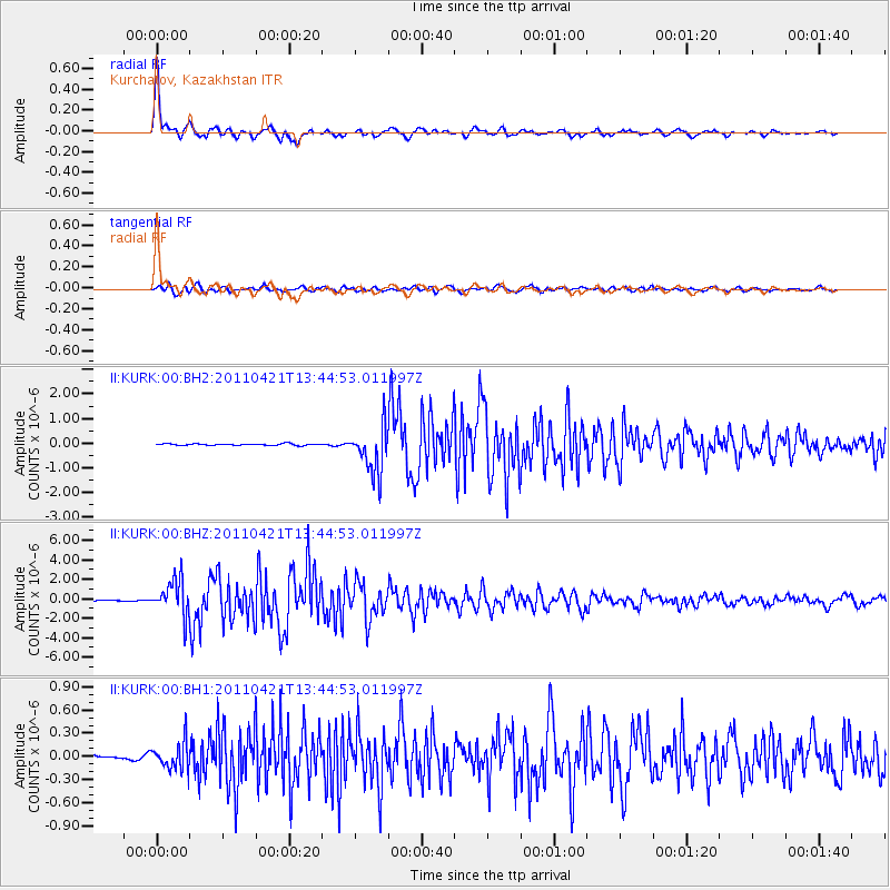
Earthquake location: Near East Coast Of Honshu, Japan
Earthquake latitude/longitude: 35.6/140.3
Earthquake time(UTC): 2011/04/21 (111) 13:37:03 GMT
Earthquake Depth: 43 km
Earthquake Magnitude: 6.2 MW, 5.7 MB, 5.8 MS, 6.2 MW
Earthquake Catalog/Contributor: NEIC PDE/NEIC PDE-M
Network: II Global Seismograph Network (GSN - IRIS/IDA)
Station: KURK Kurchatov, Kazakhstan
Lat/Lon: 50.72 N/78.62 E
Elevation: 184 m
Distance: 46.1 deg
Az: 309.085 deg
Baz: 84.447 deg
Ray Param: 0.07073004
Estimated Moho Depth: 42.25 km
Estimated Crust Vp/Vs: 1.71
Assumed Crust Vp: 6.552 km/s
Estimated Crust Vs: 3.826 km/s
Estimated Crust Poisson's Ratio: 0.24
Radial Match: 97.59566 %
Radial Bump: 378
Transverse Match: 91.95562 %
Transverse Bump: 400
SOD ConfigId: 558545
Insert Time: 2013-09-18 16:39:01.798 +0000
GWidth: 2.5
Max Bumps: 400
Tol: 0.001

Signal To Noise

ChannelStoNSTALTA
II:KURK:00:BHZ:20110421T13:44:53.011997Z24.974341.7967985E-67.1945784E-8
II:KURK:00:BH1:20110421T13:44:53.011997Z4.27506451.688711E-73.9501415E-8
II:KURK:00:BH2:20110421T13:44:53.011997Z30.6631019.684203E-73.158259E-8
Arrivals
Ps4.9 SECOND
PpPs16 SECOND
PsPs/PpSs21 SECOND