You are here: Home > Network List > CN - Canadian National Seismograph Network Stations List
> Station GAC GLEN ALMOND, QUE. > Earthquake Result Viewer
GAC GLEN ALMOND, QUE. - Earthquake Result Viewer
| Earthquake location: |
Near Coast Of Guerrero, Mexico |
| Earthquake latitude/longitude: |
16.7/-98.4 |
| Earthquake time(UTC): |
1993/05/15 (135) 03:12:33 GMT |
| Earthquake Depth: |
28 km |
| Earthquake Magnitude: |
5.9 MB, 5.9 MS |
| Earthquake Catalog/Contributor: |
WHDF/NEIC |
|
| Network: |
CN Canadian National Seismograph Network |
| Station: |
GAC GLEN ALMOND, QUE. |
| Lat/Lon: |
45.70 N/75.48 W |
| Elevation: |
62 m |
|
| Distance: |
34.6 deg |
| Az: |
28.651 deg |
| Baz: |
220.964 deg |
| Ray Param: |
0.07759546 |
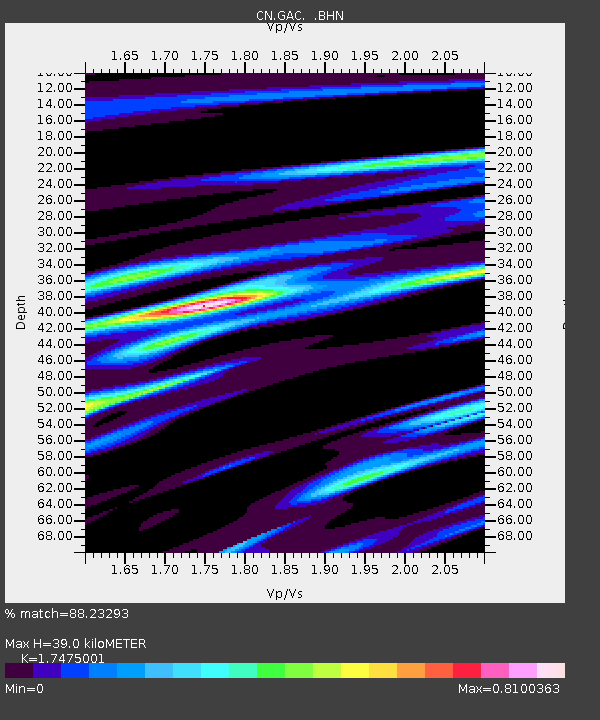
| Estimated Moho Depth: |
39.0 km |
| Estimated Crust Vp/Vs: |
1.75 |
| Assumed Crust Vp: |
6.419 km/s |
| Estimated Crust Vs: |
3.673 km/s |
| Estimated Crust Poisson's Ratio: |
0.26 |
|
| Radial Match: |
88.23293 % |
| Radial Bump: |
319 |
| Transverse Match: |
70.07615 % |
| Transverse Bump: |
400 |
| SOD ConfigId: |
4480 |
| Insert Time: |
2010-02-27 05:58:11.556 +0000 |
| GWidth: |
2.5 |
| Max Bumps: |
400 |
| Tol: |
0.001 |
|

Signal To Noise
| Channel | StoN | STA | LTA |
| CN:GAC: :BHN:19930515T03:18:50.150Z | 4.44635 | 4.6562578E-5 | 1.047209E-5 |
| CN:GAC: :BHE:19930515T03:18:50.150Z | 1.6195801 | 1.7648987E-5 | 1.089726E-5 |
| CN:GAC: :BHZ:19930515T03:18:50.150Z | 2.5796943 | 2.0463165E-5 | 7.9324E-6 |
| Arrivals |
| Ps | 4.9 SECOND |
| PpPs | 15 SECOND |
| PsPs/PpSs | 20 SECOND |


