You are here: Home > Network List > IU - Global Seismograph Network (GSN - IRIS/USGS) Stations List
> Station RSSD Black Hills, South Dakota, USA > Earthquake Result Viewer
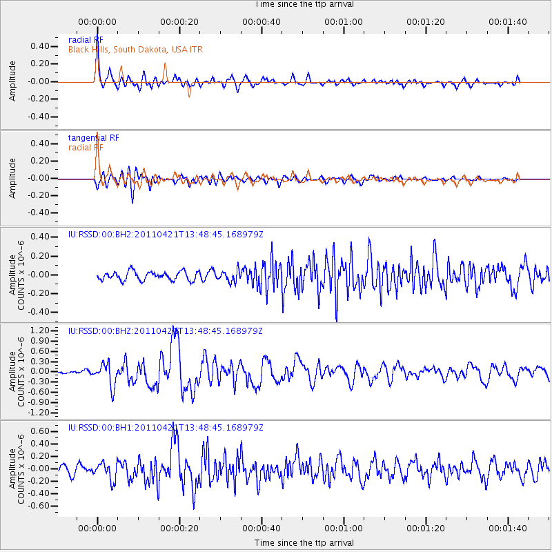
RSSD Black Hills, South Dakota, USA - Earthquake Result Viewer
*The percent match for this event was below the threshold and hence no stack was calculated.
| Earthquake location: |
Near East Coast Of Honshu, Japan |
| Earthquake latitude/longitude: |
35.6/140.3 |
| Earthquake time(UTC): |
2011/04/21 (111) 13:37:03 GMT |
| Earthquake Depth: |
43 km |
| Earthquake Magnitude: |
6.2 MW, 5.7 MB, 5.8 MS, 6.2 MW |
| Earthquake Catalog/Contributor: |
NEIC PDE/NEIC PDE-M |
|
| Network: |
IU Global Seismograph Network (GSN - IRIS/USGS) |
| Station: |
RSSD Black Hills, South Dakota, USA |
| Lat/Lon: |
44.12 N/104.04 W |
| Elevation: |
2090 m |
|
| Distance: |
81.5 deg |
| Az: |
41.024 deg |
| Baz: |
312.02 deg |
| Ray Param: |
$rayparam |
*The percent match for this event was below the threshold and hence was not used in the summary stack. |
|
| Radial Match: |
79.47432 % |
| Radial Bump: |
400 |
| Transverse Match: |
77.54037 % |
| Transverse Bump: |
400 |
| SOD ConfigId: |
558545 |
| Insert Time: |
2013-09-18 16:40:00.780 +0000 |
| GWidth: |
2.5 |
| Max Bumps: |
400 |
| Tol: |
0.001 |
|
Signal To Noise
| Channel | StoN | STA | LTA |
| IU:RSSD:00:BHZ:20110421T13:48:45.168979Z | 6.296496 | 3.3769766E-7 | 5.3632633E-8 |
| IU:RSSD:00:BH1:20110421T13:48:45.168979Z | 2.0159032 | 1.4466121E-7 | 7.175999E-8 |
| IU:RSSD:00:BH2:20110421T13:48:45.168979Z | 1.2484156 | 5.7730436E-8 | 4.6242963E-8 |
| Arrivals |
| Ps | |
| PpPs | |
| PsPs/PpSs | |


