You are here: Home > Network List > CN - Canadian National Seismograph Network Stations List
> Station GAC GLEN ALMOND, QUE. > Earthquake Result Viewer
GAC GLEN ALMOND, QUE. - Earthquake Result Viewer
| Earthquake location: |
Chiapas, Mexico |
| Earthquake latitude/longitude: |
16.9/-93.5 |
| Earthquake time(UTC): |
1995/10/21 (294) 02:38:57 GMT |
| Earthquake Depth: |
161 km |
| Earthquake Magnitude: |
6.2 MB, 7.3 UNKNOWN, 7.3 MW |
| Earthquake Catalog/Contributor: |
WHDF/NEIC |
|
| Network: |
CN Canadian National Seismograph Network |
| Station: |
GAC GLEN ALMOND, QUE. |
| Lat/Lon: |
45.70 N/75.48 W |
| Elevation: |
62 m |
|
| Distance: |
32.4 deg |
| Az: |
23.789 deg |
| Baz: |
213.442 deg |
| Ray Param: |
0.07817784 |
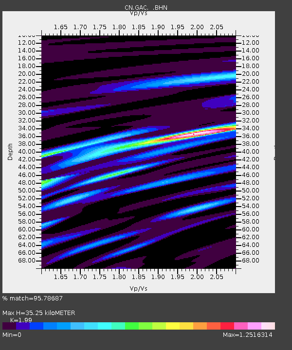
| Estimated Moho Depth: |
35.25 km |
| Estimated Crust Vp/Vs: |
1.99 |
| Assumed Crust Vp: |
6.419 km/s |
| Estimated Crust Vs: |
3.226 km/s |
| Estimated Crust Poisson's Ratio: |
0.33 |
|
| Radial Match: |
95.78687 % |
| Radial Bump: |
266 |
| Transverse Match: |
87.40525 % |
| Transverse Bump: |
400 |
| SOD ConfigId: |
6273 |
| Insert Time: |
2010-02-27 05:58:15.483 +0000 |
| GWidth: |
2.5 |
| Max Bumps: |
400 |
| Tol: |
0.001 |
|

Signal To Noise
| Channel | StoN | STA | LTA |
| CN:GAC: :BHN:19951021T02:44:41.875Z | 3.518652 | 4640.854 | 1318.9296 |
| CN:GAC: :BHE:19951021T02:44:41.875Z | 2.1839113 | 5901.407 | 2702.2192 |
| CN:GAC: :BHZ:19951021T02:44:41.875Z | 3.5480914 | 11133.081 | 3137.766 |
| Arrivals |
| Ps | 5.8 SECOND |
| PpPs | 15 SECOND |
| PsPs/PpSs | 21 SECOND |


