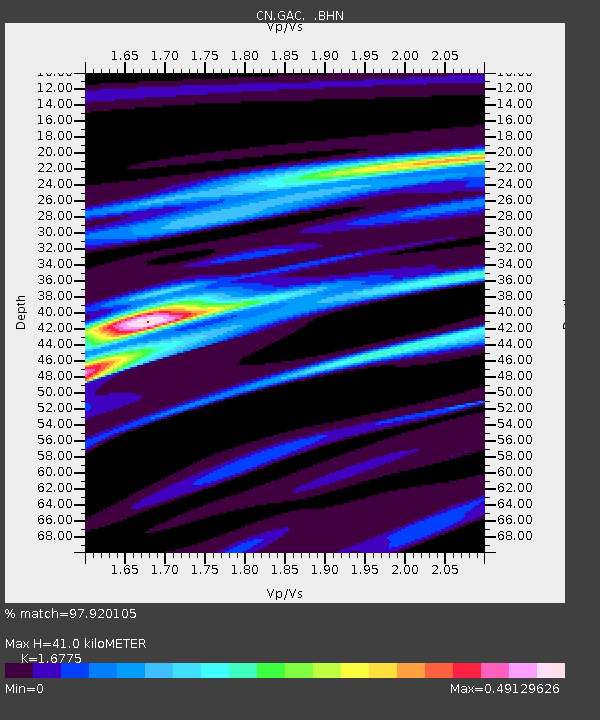
GAC GLEN ALMOND, QUE. - Earthquake Result Viewer

Earthquake location: Near Coast Of Guerrero, Mexico
Earthquake latitude/longitude: 16.8/-98.6
Earthquake time(UTC): 1995/09/14 (257) 14:04:31 GMT
Earthquake Depth: 21 km
Earthquake Magnitude: 6.4 MB, 7.2 MS, 7.2 UNKNOWN, 7.5 MW
Earthquake Catalog/Contributor: WHDF/NEIC
Network: CN Canadian National Seismograph Network
Station: GAC GLEN ALMOND, QUE.
Lat/Lon: 45.70 N/75.48 W
Elevation: 62 m
Distance: 34.7 deg
Az: 28.945 deg
Baz: 221.403 deg
Ray Param: 0.077605166
Estimated Moho Depth: 41.0 km
Estimated Crust Vp/Vs: 1.68
Assumed Crust Vp: 6.419 km/s
Estimated Crust Vs: 3.827 km/s
Estimated Crust Poisson's Ratio: 0.22
Radial Match: 97.920105 %
Radial Bump: 234
Transverse Match: 88.88783 %
Transverse Bump: 400
SOD ConfigId: 6273
Insert Time: 2010-02-27 05:58:21.586 +0000
GWidth: 2.5
Max Bumps: 400
Tol: 0.001

Signal To Noise

ChannelStoNSTALTA
CN:GAC: :BHN:19950914T14:10:48.774011Z12.79397419233.6541503.337
CN:GAC: :BHE:19950914T14:10:48.774011Z20.10791421952.5271091.7357
CN:GAC: :BHZ:19950914T14:10:48.774011Z34.5740651200.821480.9028
Arrivals
Ps4.7 SECOND
PpPs16 SECOND
PsPs/PpSs20 SECOND