You are here: Home > Network List > IU - Global Seismograph Network (GSN - IRIS/USGS) Stations List
> Station MAKZ Makanchi, Kazakhstan > Earthquake Result Viewer
MAKZ Makanchi, Kazakhstan - Earthquake Result Viewer
| Earthquake location: |
Solomon Islands |
| Earthquake latitude/longitude: |
-10.4/161.2 |
| Earthquake time(UTC): |
2011/04/23 (113) 04:16:54 GMT |
| Earthquake Depth: |
79 km |
| Earthquake Magnitude: |
6.7 MB, 6.8 MW, 6.8 MW |
| Earthquake Catalog/Contributor: |
WHDF/NEIC |
|
| Network: |
IU Global Seismograph Network (GSN - IRIS/USGS) |
| Station: |
MAKZ Makanchi, Kazakhstan |
| Lat/Lon: |
46.81 N/81.98 E |
| Elevation: |
600 m |
|
| Distance: |
90.2 deg |
| Az: |
317.563 deg |
| Baz: |
104.869 deg |
| Ray Param: |
0.041675046 |
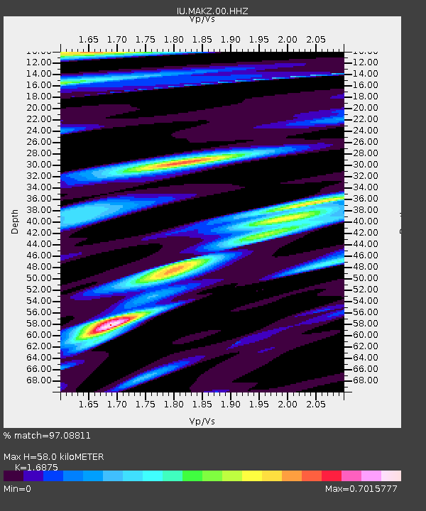
| Estimated Moho Depth: |
58.0 km |
| Estimated Crust Vp/Vs: |
1.69 |
| Assumed Crust Vp: |
6.571 km/s |
| Estimated Crust Vs: |
3.894 km/s |
| Estimated Crust Poisson's Ratio: |
0.23 |
|
| Radial Match: |
97.08811 % |
| Radial Bump: |
366 |
| Transverse Match: |
95.23978 % |
| Transverse Bump: |
400 |
| SOD ConfigId: |
558545 |
| Insert Time: |
2013-09-18 16:48:11.659 +0000 |
| GWidth: |
2.5 |
| Max Bumps: |
400 |
| Tol: |
0.001 |
|
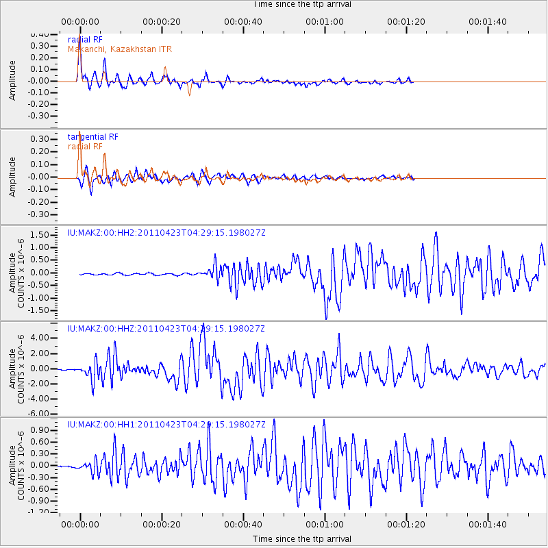
Signal To Noise
| Channel | StoN | STA | LTA |
| IU:MAKZ:00:HHZ:20110423T04:29:15.198027Z | 19.280275 | 1.1348245E-6 | 5.8859356E-8 |
| IU:MAKZ:00:HH1:20110423T04:29:15.198027Z | 4.538855 | 1.4537666E-7 | 3.202937E-8 |
| IU:MAKZ:00:HH2:20110423T04:29:15.198027Z | 7.6594067 | 2.7160573E-7 | 3.5460413E-8 |
| Arrivals |
| Ps | 6.2 SECOND |
| PpPs | 23 SECOND |
| PsPs/PpSs | 29 SECOND |


