You are here: Home > Network List > IU - Global Seismograph Network (GSN - IRIS/USGS) Stations List
> Station POHA Pohakuloa, Hawaii, USA > Earthquake Result Viewer
POHA Pohakuloa, Hawaii, USA - Earthquake Result Viewer

| Earthquake location: |
Solomon Islands |
| Earthquake latitude/longitude: |
-10.4/161.2 |
| Earthquake time(UTC): |
2011/04/23 (113) 04:16:54 GMT |
| Earthquake Depth: |
79 km |
| Earthquake Magnitude: |
6.7 MB, 6.8 MW, 6.8 MW |
| Earthquake Catalog/Contributor: |
WHDF/NEIC |
|
| Network: |
IU Global Seismograph Network (GSN - IRIS/USGS) |
| Station: |
POHA Pohakuloa, Hawaii, USA |
| Lat/Lon: |
19.76 N/155.53 W |
| Elevation: |
1990 m |
|
| Distance: |
52.1 deg |
| Az: |
54.923 deg |
| Baz: |
238.747 deg |
| Ray Param: |
0.06676082 |
| Estimated Moho Depth: |
43.0 km |
| Estimated Crust Vp/Vs: |
1.83 |
| Assumed Crust Vp: |
5.195 km/s |
| Estimated Crust Vs: |
2.843 km/s |
| Estimated Crust Poisson's Ratio: |
0.29 |
|
| Radial Match: |
84.016495 % |
| Radial Bump: |
400 |
| Transverse Match: |
82.76272 % |
| Transverse Bump: |
400 |
| SOD ConfigId: |
558545 |
| Insert Time: |
2013-09-18 16:48:14.338 +0000 |
| GWidth: |
2.5 |
| Max Bumps: |
400 |
| Tol: |
0.001 |
|
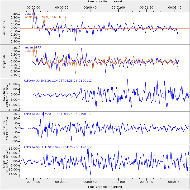
Signal To Noise
| Channel | StoN | STA | LTA |
| IU:POHA:00:BHZ:20110423T04:25:26.019011Z | 8.845866 | 7.5345533E-6 | 8.517598E-7 |
| IU:POHA:00:BH1:20110423T04:25:26.019011Z | 0.5705276 | 1.1337439E-6 | 1.987185E-6 |
| IU:POHA:00:BH2:20110423T04:25:26.019011Z | 3.1927712 | 3.0700312E-6 | 9.615569E-7 |
| Arrivals |
| Ps | 7.1 SECOND |
| PpPs | 23 SECOND |
| PsPs/PpSs | 30 SECOND |


