You are here: Home > Network List > GS - US Geological Survey Networks Stations List
> Station KAN13 Rinehart Farm > Earthquake Result Viewer
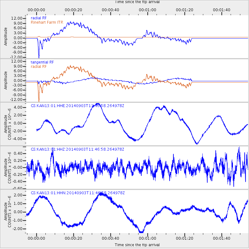
KAN13 Rinehart Farm - Earthquake Result Viewer
*The percent match for this event was below the threshold and hence no stack was calculated.
| Earthquake location: |
Samoa Islands |
| Earthquake latitude/longitude: |
-14.9/-172.9 |
| Earthquake time(UTC): |
2014/09/03 (246) 11:34:40 GMT |
| Earthquake Depth: |
10 km |
| Earthquake Magnitude: |
5.7 MWW, 5.7 MWC, 5.7 MWB |
| Earthquake Catalog/Contributor: |
NEIC PDE/NEIC COMCAT |
|
| Network: |
GS US Geological Survey Networks |
| Station: |
KAN13 Rinehart Farm |
| Lat/Lon: |
37.01 N/97.48 W |
| Elevation: |
340 m |
|
| Distance: |
87.6 deg |
| Az: |
50.837 deg |
| Baz: |
249.457 deg |
| Ray Param: |
$rayparam |
*The percent match for this event was below the threshold and hence was not used in the summary stack. |
|
| Radial Match: |
51.136253 % |
| Radial Bump: |
400 |
| Transverse Match: |
60.7341 % |
| Transverse Bump: |
400 |
| SOD ConfigId: |
3390531 |
| Insert Time: |
2019-04-13 19:41:53.939 +0000 |
| GWidth: |
2.5 |
| Max Bumps: |
400 |
| Tol: |
0.001 |
|
Signal To Noise
| Channel | StoN | STA | LTA |
| GS:KAN13:01:HHZ:20140903T11:46:58.264978Z | 1.5558118 | 1.740786E-7 | 1.11889236E-7 |
| GS:KAN13:01:HHN:20140903T11:46:58.264978Z | 8.182329 | 2.17968E-6 | 2.663887E-7 |
| GS:KAN13:01:HHE:20140903T11:46:58.264978Z | 5.295172 | 5.249015E-6 | 9.912832E-7 |
| Arrivals |
| Ps | |
| PpPs | |
| PsPs/PpSs | |


