You are here: Home > Network List > IU - Global Seismograph Network (GSN - IRIS/USGS) Stations List
> Station HNR Honiara, Solomon Islands > Earthquake Result Viewer
HNR Honiara, Solomon Islands - Earthquake Result Viewer
| Earthquake location: |
Sulawesi, Indonesia |
| Earthquake latitude/longitude: |
-4.6/122.8 |
| Earthquake time(UTC): |
2011/04/24 (114) 23:07:51 GMT |
| Earthquake Depth: |
8.0 km |
| Earthquake Magnitude: |
5.7 MB, 5.8 MS, 6.1 MW, 6.1 MW |
| Earthquake Catalog/Contributor: |
WHDF/NEIC |
|
| Network: |
IU Global Seismograph Network (GSN - IRIS/USGS) |
| Station: |
HNR Honiara, Solomon Islands |
| Lat/Lon: |
9.44 S/159.95 E |
| Elevation: |
100 m |
|
| Distance: |
37.2 deg |
| Az: |
99.519 deg |
| Baz: |
274.843 deg |
| Ray Param: |
0.076273404 |
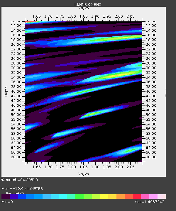
| Estimated Moho Depth: |
10.0 km |
| Estimated Crust Vp/Vs: |
1.64 |
| Assumed Crust Vp: |
6.183 km/s |
| Estimated Crust Vs: |
3.764 km/s |
| Estimated Crust Poisson's Ratio: |
0.21 |
|
| Radial Match: |
84.30513 % |
| Radial Bump: |
400 |
| Transverse Match: |
85.475784 % |
| Transverse Bump: |
400 |
| SOD ConfigId: |
558545 |
| Insert Time: |
2013-09-18 16:54:20.975 +0000 |
| GWidth: |
2.5 |
| Max Bumps: |
400 |
| Tol: |
0.001 |
|
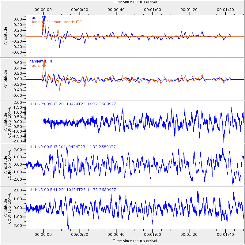
Signal To Noise
| Channel | StoN | STA | LTA |
| IU:HNR:00:BHZ:20110424T23:14:32.268992Z | 3.7537656 | 8.091011E-7 | 2.1554386E-7 |
| IU:HNR:00:BH1:20110424T23:14:32.268992Z | 1.721564 | 3.5878506E-7 | 2.0840645E-7 |
| IU:HNR:00:BH2:20110424T23:14:32.268992Z | 2.088435 | 4.447019E-7 | 2.1293548E-7 |
| Arrivals |
| Ps | 1.1 SECOND |
| PpPs | 4.0 SECOND |
| PsPs/PpSs | 5.1 SECOND |


