You are here: Home > Network List > TA - USArray Transportable Network (new EarthScope stations) Stations List
> Station N23A Red Feather Lakes, CO, USA > Earthquake Result Viewer
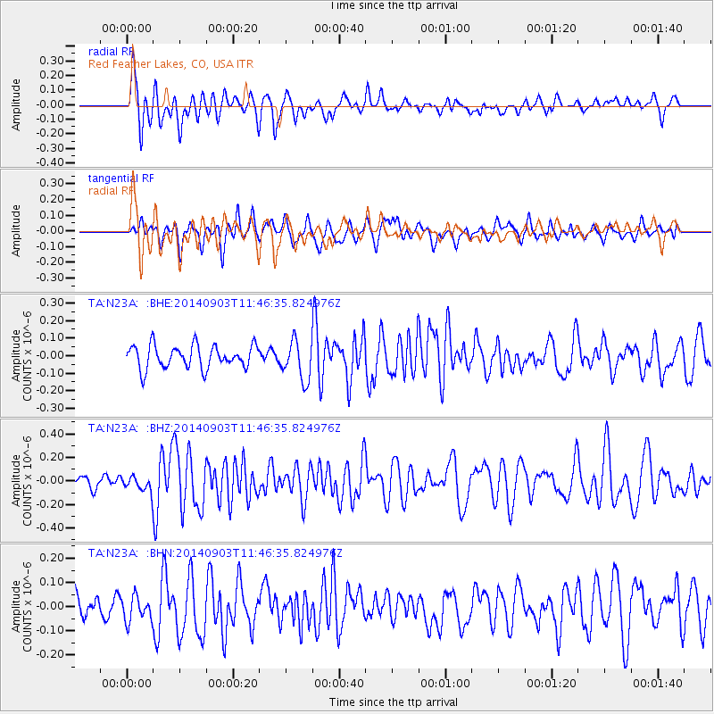
N23A Red Feather Lakes, CO, USA - Earthquake Result Viewer
*The percent match for this event was below the threshold and hence no stack was calculated.
| Earthquake location: |
Samoa Islands |
| Earthquake latitude/longitude: |
-14.9/-172.9 |
| Earthquake time(UTC): |
2014/09/03 (246) 11:34:40 GMT |
| Earthquake Depth: |
10 km |
| Earthquake Magnitude: |
5.7 MWW, 5.7 MWC, 5.7 MWB |
| Earthquake Catalog/Contributor: |
NEIC PDE/NEIC COMCAT |
|
| Network: |
TA USArray Transportable Network (new EarthScope stations) |
| Station: |
N23A Red Feather Lakes, CO, USA |
| Lat/Lon: |
40.89 N/105.94 W |
| Elevation: |
2458 m |
|
| Distance: |
83.1 deg |
| Az: |
44.643 deg |
| Baz: |
243.646 deg |
| Ray Param: |
$rayparam |
*The percent match for this event was below the threshold and hence was not used in the summary stack. |
|
| Radial Match: |
64.28491 % |
| Radial Bump: |
400 |
| Transverse Match: |
49.007793 % |
| Transverse Bump: |
400 |
| SOD ConfigId: |
3390531 |
| Insert Time: |
2019-04-13 19:43:48.586 +0000 |
| GWidth: |
2.5 |
| Max Bumps: |
400 |
| Tol: |
0.001 |
|
Signal To Noise
| Channel | StoN | STA | LTA |
| TA:N23A: :BHZ:20140903T11:46:35.824976Z | 1.1141323 | 5.8299637E-8 | 5.2327394E-8 |
| TA:N23A: :BHN:20140903T11:46:35.824976Z | 0.8711108 | 5.2278963E-8 | 6.001413E-8 |
| TA:N23A: :BHE:20140903T11:46:35.824976Z | 1.4136683 | 9.0391644E-8 | 6.39412E-8 |
| Arrivals |
| Ps | |
| PpPs | |
| PsPs/PpSs | |


