You are here: Home > Network List > IU - Global Seismograph Network (GSN - IRIS/USGS) Stations List
> Station PMG Port Moresby, New Guinea > Earthquake Result Viewer
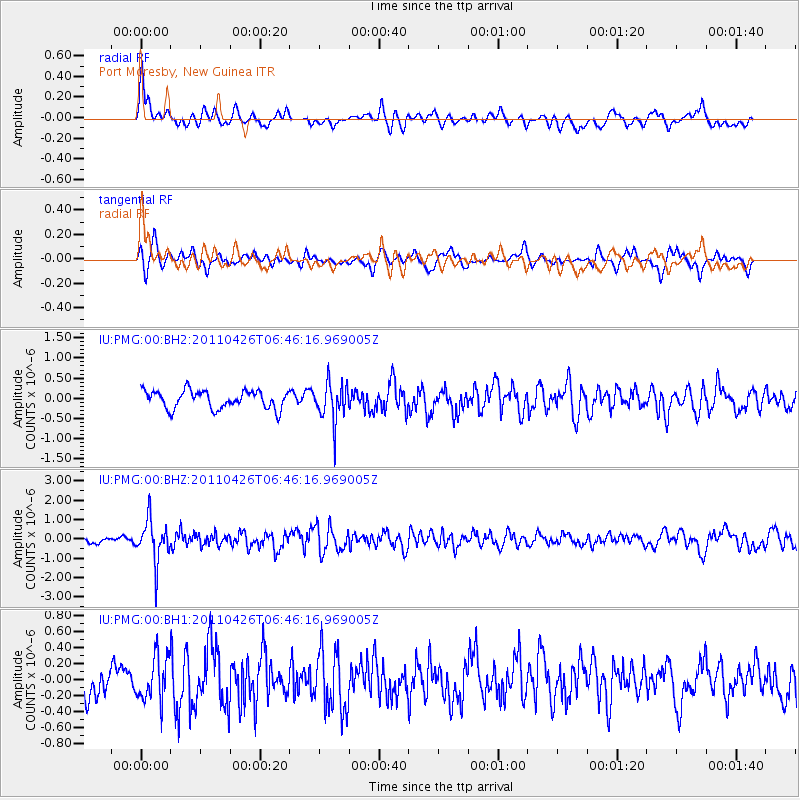
PMG Port Moresby, New Guinea - Earthquake Result Viewer
*The percent match for this event was below the threshold and hence no stack was calculated.
| Earthquake location: |
Java, Indonesia |
| Earthquake latitude/longitude: |
-8.1/108.5 |
| Earthquake time(UTC): |
2011/04/26 (116) 06:39:36 GMT |
| Earthquake Depth: |
95 km |
| Earthquake Magnitude: |
5.6 MW, 5.6 MW, 5.7 MB |
| Earthquake Catalog/Contributor: |
NEIC PDE/NEIC PDE-M |
|
| Network: |
IU Global Seismograph Network (GSN - IRIS/USGS) |
| Station: |
PMG Port Moresby, New Guinea |
| Lat/Lon: |
9.40 S/147.16 E |
| Elevation: |
90 m |
|
| Distance: |
38.2 deg |
| Az: |
94.929 deg |
| Baz: |
268.86 deg |
| Ray Param: |
$rayparam |
*The percent match for this event was below the threshold and hence was not used in the summary stack. |
|
| Radial Match: |
69.06649 % |
| Radial Bump: |
400 |
| Transverse Match: |
67.57152 % |
| Transverse Bump: |
400 |
| SOD ConfigId: |
558545 |
| Insert Time: |
2013-09-18 16:56:20.493 +0000 |
| GWidth: |
2.5 |
| Max Bumps: |
400 |
| Tol: |
0.001 |
|
Signal To Noise
| Channel | StoN | STA | LTA |
| IU:PMG:00:BHZ:20110426T06:46:16.969005Z | 7.8087993 | 1.0780346E-6 | 1.3805384E-7 |
| IU:PMG:00:BH1:20110426T06:46:16.969005Z | 1.3398802 | 2.808442E-7 | 2.0960395E-7 |
| IU:PMG:00:BH2:20110426T06:46:16.969005Z | 2.1473396 | 4.7776433E-7 | 2.2249128E-7 |
| Arrivals |
| Ps | |
| PpPs | |
| PsPs/PpSs | |


