You are here: Home > Network List > IU - Global Seismograph Network (GSN - IRIS/USGS) Stations List
> Station HNR Honiara, Solomon Islands > Earthquake Result Viewer
HNR Honiara, Solomon Islands - Earthquake Result Viewer
*The percent match for this event was below the threshold and hence no stack was calculated.
| Earthquake location: |
Timor Region |
| Earthquake latitude/longitude: |
-8.8/125.7 |
| Earthquake time(UTC): |
2011/04/26 (116) 21:43:47 GMT |
| Earthquake Depth: |
9.8 km |
| Earthquake Magnitude: |
5.5 MB |
| Earthquake Catalog/Contributor: |
NEIC PDE/NEIC PDE-M |
|
| Network: |
IU Global Seismograph Network (GSN - IRIS/USGS) |
| Station: |
HNR Honiara, Solomon Islands |
| Lat/Lon: |
9.44 S/159.95 E |
| Elevation: |
100 m |
|
| Distance: |
33.9 deg |
| Az: |
93.808 deg |
| Baz: |
268.243 deg |
| Ray Param: |
$rayparam |
*The percent match for this event was below the threshold and hence was not used in the summary stack. |
|
| Radial Match: |
45.806877 % |
| Radial Bump: |
400 |
| Transverse Match: |
42.033276 % |
| Transverse Bump: |
400 |
| SOD ConfigId: |
558545 |
| Insert Time: |
2013-09-18 17:00:09.663 +0000 |
| GWidth: |
2.5 |
| Max Bumps: |
400 |
| Tol: |
0.001 |
|
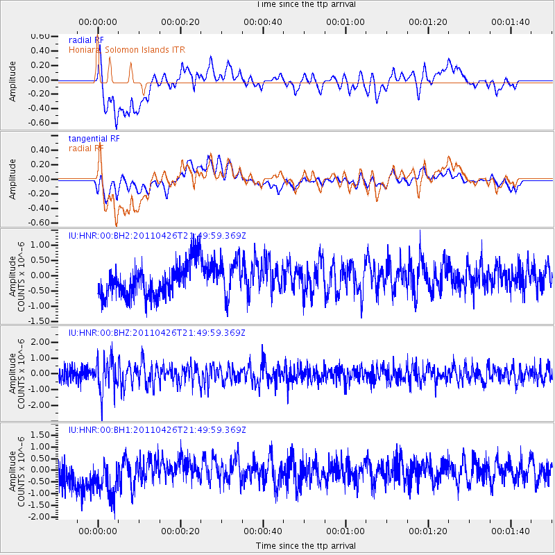
Signal To Noise
| Channel | StoN | STA | LTA |
| IU:HNR:00:BHZ:20110426T21:49:59.369Z | 2.7670743 | 1.0315182E-6 | 3.72783E-7 |
| IU:HNR:00:BH1:20110426T21:49:59.369Z | 1.9926921 | 9.471387E-7 | 4.7530605E-7 |
| IU:HNR:00:BH2:20110426T21:49:59.369Z | 1.1178911 | 5.9266563E-7 | 5.30164E-7 |
| Arrivals |
| Ps | |
| PpPs | |
| PsPs/PpSs | |


