You are here: Home > Network List > II - Global Seismograph Network (GSN - IRIS/IDA) Stations List
> Station WRAB Tennant Creek, NT, Australia > Earthquake Result Viewer
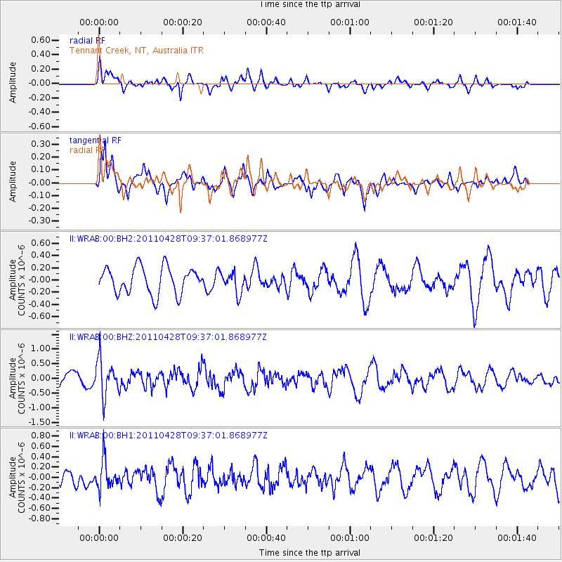
WRAB Tennant Creek, NT, Australia - Earthquake Result Viewer
*The percent match for this event was below the threshold and hence no stack was calculated.
| Earthquake location: |
Near East Coast Of Honshu, Japan |
| Earthquake latitude/longitude: |
37.5/141.7 |
| Earthquake time(UTC): |
2011/04/28 (118) 09:27:47 GMT |
| Earthquake Depth: |
38 km |
| Earthquake Magnitude: |
5.8 MB, 5.1 MS, 5.6 MW, 5.5 MW |
| Earthquake Catalog/Contributor: |
WHDF/NEIC |
|
| Network: |
II Global Seismograph Network (GSN - IRIS/IDA) |
| Station: |
WRAB Tennant Creek, NT, Australia |
| Lat/Lon: |
19.93 S/134.36 E |
| Elevation: |
366 m |
|
| Distance: |
57.5 deg |
| Az: |
188.142 deg |
| Baz: |
6.88 deg |
| Ray Param: |
$rayparam |
*The percent match for this event was below the threshold and hence was not used in the summary stack. |
|
| Radial Match: |
54.98892 % |
| Radial Bump: |
400 |
| Transverse Match: |
64.055084 % |
| Transverse Bump: |
387 |
| SOD ConfigId: |
558545 |
| Insert Time: |
2013-09-18 17:02:30.642 +0000 |
| GWidth: |
2.5 |
| Max Bumps: |
400 |
| Tol: |
0.001 |
|
Signal To Noise
| Channel | StoN | STA | LTA |
| II:WRAB:00:BHZ:20110428T09:37:01.868977Z | 3.0419009 | 6.2810176E-7 | 2.064833E-7 |
| II:WRAB:00:BH1:20110428T09:37:01.868977Z | 1.4737066 | 2.8618746E-7 | 1.9419568E-7 |
| II:WRAB:00:BH2:20110428T09:37:01.868977Z | 0.8055892 | 1.7598205E-7 | 2.1845135E-7 |
| Arrivals |
| Ps | |
| PpPs | |
| PsPs/PpSs | |


