You are here: Home > Network List > KZ - Kazakhstan Network Stations List
> Station KUR21 Cross-array, Kurchatov, Kazakstan > Earthquake Result Viewer
KUR21 Cross-array, Kurchatov, Kazakstan - Earthquake Result Viewer
| Earthquake location: |
Near East Coast Of Honshu, Japan |
| Earthquake latitude/longitude: |
37.5/141.7 |
| Earthquake time(UTC): |
2011/04/28 (118) 09:27:47 GMT |
| Earthquake Depth: |
38 km |
| Earthquake Magnitude: |
5.8 MB, 5.1 MS, 5.6 MW, 5.5 MW |
| Earthquake Catalog/Contributor: |
WHDF/NEIC |
|
| Network: |
KZ Kazakhstan Network |
| Station: |
KUR21 Cross-array, Kurchatov, Kazakstan |
| Lat/Lon: |
50.62 N/78.53 E |
| Elevation: |
200 m |
|
| Distance: |
45.9 deg |
| Az: |
307.697 deg |
| Baz: |
81.319 deg |
| Ray Param: |
0.07090041 |
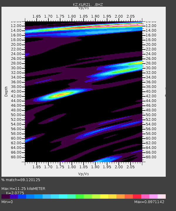
| Estimated Moho Depth: |
11.25 km |
| Estimated Crust Vp/Vs: |
2.08 |
| Assumed Crust Vp: |
6.552 km/s |
| Estimated Crust Vs: |
3.154 km/s |
| Estimated Crust Poisson's Ratio: |
0.35 |
|
| Radial Match: |
89.120125 % |
| Radial Bump: |
400 |
| Transverse Match: |
90.08603 % |
| Transverse Bump: |
400 |
| SOD ConfigId: |
558545 |
| Insert Time: |
2013-09-18 17:03:39.024 +0000 |
| GWidth: |
2.5 |
| Max Bumps: |
400 |
| Tol: |
0.001 |
|

Signal To Noise
| Channel | StoN | STA | LTA |
| KZ:KUR21: :BHZ:20110428T09:35:35.499989Z | 15.08766 | 7.290377E-7 | 4.8320132E-8 |
| KZ:KUR21: :BH1:20110428T09:35:35.499989Z | 9.461608 | 3.5734982E-7 | 3.77684E-8 |
| KZ:KUR21: :BH2:20110428T09:35:35.499989Z | 3.2178695 | 1.4099572E-7 | 4.381648E-8 |
| Arrivals |
| Ps | 2.0 SECOND |
| PpPs | 5.0 SECOND |
| PsPs/PpSs | 7.0 SECOND |


