You are here: Home > Network List > II - Global Seismograph Network (GSN - IRIS/IDA) Stations List
> Station WRAB Tennant Creek, NT, Australia > Earthquake Result Viewer
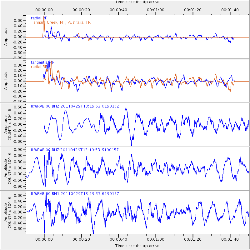
WRAB Tennant Creek, NT, Australia - Earthquake Result Viewer
*The percent match for this event was below the threshold and hence no stack was calculated.
| Earthquake location: |
Taiwan Region |
| Earthquake latitude/longitude: |
21.1/122.0 |
| Earthquake time(UTC): |
2011/04/29 (119) 13:12:46 GMT |
| Earthquake Depth: |
181 km |
| Earthquake Magnitude: |
5.5 MB, 5.4 MW, 5.3 MW |
| Earthquake Catalog/Contributor: |
WHDF/NEIC |
|
| Network: |
II Global Seismograph Network (GSN - IRIS/IDA) |
| Station: |
WRAB Tennant Creek, NT, Australia |
| Lat/Lon: |
19.93 S/134.36 E |
| Elevation: |
366 m |
|
| Distance: |
42.6 deg |
| Az: |
162.691 deg |
| Baz: |
342.829 deg |
| Ray Param: |
$rayparam |
*The percent match for this event was below the threshold and hence was not used in the summary stack. |
|
| Radial Match: |
58.904465 % |
| Radial Bump: |
400 |
| Transverse Match: |
73.62418 % |
| Transverse Bump: |
400 |
| SOD ConfigId: |
558545 |
| Insert Time: |
2013-09-18 17:07:22.588 +0000 |
| GWidth: |
2.5 |
| Max Bumps: |
400 |
| Tol: |
0.001 |
|
Signal To Noise
| Channel | StoN | STA | LTA |
| II:WRAB:00:BHZ:20110429T13:19:53.619015Z | 1.9920163 | 5.304623E-7 | 2.6629417E-7 |
| II:WRAB:00:BH1:20110429T13:19:53.619015Z | 2.1265633 | 3.626173E-7 | 1.7051798E-7 |
| II:WRAB:00:BH2:20110429T13:19:53.619015Z | 0.9351071 | 2.25972E-7 | 2.4165362E-7 |
| Arrivals |
| Ps | |
| PpPs | |
| PsPs/PpSs | |


