You are here: Home > Network List > IU - Global Seismograph Network (GSN - IRIS/USGS) Stations List
> Station RSSD Black Hills, South Dakota, USA > Earthquake Result Viewer
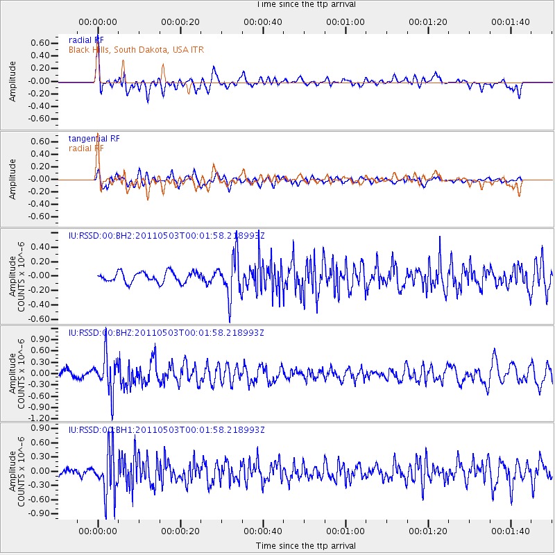
RSSD Black Hills, South Dakota, USA - Earthquake Result Viewer
*The percent match for this event was below the threshold and hence no stack was calculated.
| Earthquake location: |
Near Coast Of Nicaragua |
| Earthquake latitude/longitude: |
12.1/-87.5 |
| Earthquake time(UTC): |
2011/05/02 (122) 23:55:39 GMT |
| Earthquake Depth: |
28 km |
| Earthquake Magnitude: |
5.5 MW, 5.6 MB |
| Earthquake Catalog/Contributor: |
NEIC PDE/NEIC PDE-M |
|
| Network: |
IU Global Seismograph Network (GSN - IRIS/USGS) |
| Station: |
RSSD Black Hills, South Dakota, USA |
| Lat/Lon: |
44.12 N/104.04 W |
| Elevation: |
2090 m |
|
| Distance: |
34.9 deg |
| Az: |
338.98 deg |
| Baz: |
150.851 deg |
| Ray Param: |
$rayparam |
*The percent match for this event was below the threshold and hence was not used in the summary stack. |
|
| Radial Match: |
73.00691 % |
| Radial Bump: |
400 |
| Transverse Match: |
61.886936 % |
| Transverse Bump: |
400 |
| SOD ConfigId: |
558545 |
| Insert Time: |
2013-09-18 17:14:12.901 +0000 |
| GWidth: |
2.5 |
| Max Bumps: |
400 |
| Tol: |
0.001 |
|
Signal To Noise
| Channel | StoN | STA | LTA |
| IU:RSSD:00:BHZ:20110503T00:01:58.218993Z | 5.8502283 | 5.0535414E-7 | 8.638195E-8 |
| IU:RSSD:00:BH1:20110503T00:01:58.218993Z | 5.798358 | 4.789887E-7 | 8.260764E-8 |
| IU:RSSD:00:BH2:20110503T00:01:58.218993Z | 4.0869126 | 2.9241508E-7 | 7.1549145E-8 |
| Arrivals |
| Ps | |
| PpPs | |
| PsPs/PpSs | |


