You are here: Home > Network List > US - United States National Seismic Network Stations List
> Station ERPA Erie, Pennsylvania, USA > Earthquake Result Viewer
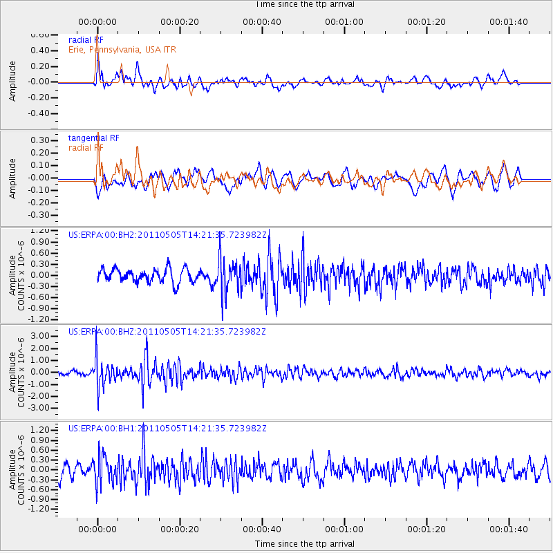
ERPA Erie, Pennsylvania, USA - Earthquake Result Viewer
*The percent match for this event was below the threshold and hence no stack was calculated.
| Earthquake location: |
Alaska Peninsula |
| Earthquake latitude/longitude: |
55.1/-160.5 |
| Earthquake time(UTC): |
2011/05/05 (125) 14:13:01 GMT |
| Earthquake Depth: |
39 km |
| Earthquake Magnitude: |
5.9 MB, 5.3 MS, 5.7 MW, 5.7 MW |
| Earthquake Catalog/Contributor: |
WHDF/NEIC |
|
| Network: |
US United States National Seismic Network |
| Station: |
ERPA Erie, Pennsylvania, USA |
| Lat/Lon: |
42.12 N/79.99 W |
| Elevation: |
306 m |
|
| Distance: |
51.9 deg |
| Az: |
68.838 deg |
| Baz: |
313.905 deg |
| Ray Param: |
$rayparam |
*The percent match for this event was below the threshold and hence was not used in the summary stack. |
|
| Radial Match: |
54.34741 % |
| Radial Bump: |
400 |
| Transverse Match: |
60.924488 % |
| Transverse Bump: |
400 |
| SOD ConfigId: |
558545 |
| Insert Time: |
2013-09-18 17:23:43.859 +0000 |
| GWidth: |
2.5 |
| Max Bumps: |
400 |
| Tol: |
0.001 |
|
Signal To Noise
| Channel | StoN | STA | LTA |
| US:ERPA:00:BHZ:20110505T14:21:35.723982Z | 5.936733 | 1.1624861E-6 | 1.9581243E-7 |
| US:ERPA:00:BH1:20110505T14:21:35.723982Z | 2.2952538 | 4.2644962E-7 | 1.8579628E-7 |
| US:ERPA:00:BH2:20110505T14:21:35.723982Z | 2.6412728 | 4.7300912E-7 | 1.7908377E-7 |
| Arrivals |
| Ps | |
| PpPs | |
| PsPs/PpSs | |


