You are here: Home > Network List > US - United States National Seismic Network Stations List
> Station MNTX Cornudas Mountains, Texas, USA > Earthquake Result Viewer
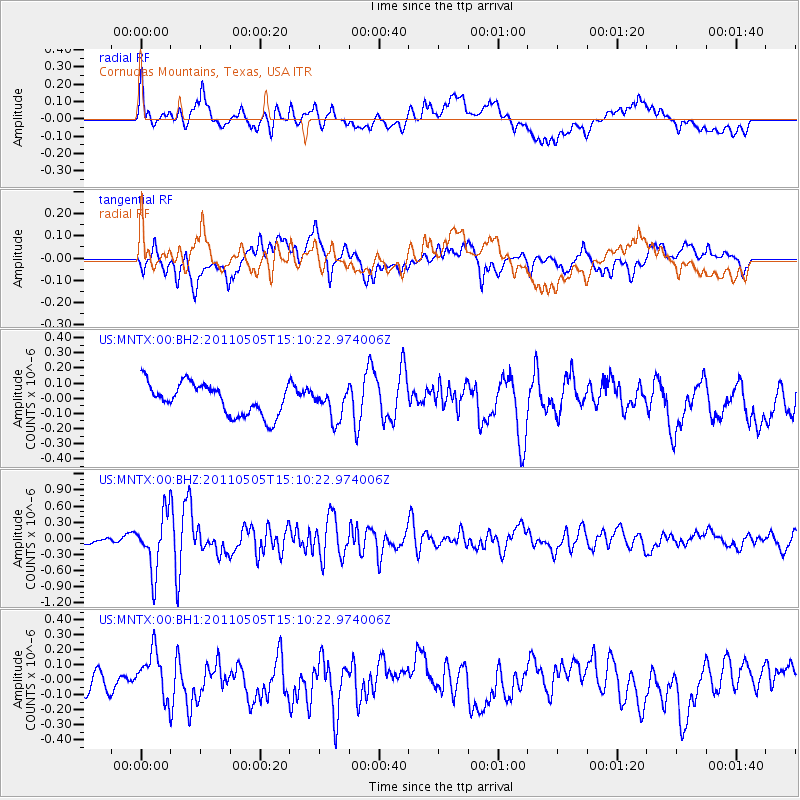
MNTX Cornudas Mountains, Texas, USA - Earthquake Result Viewer
*The percent match for this event was below the threshold and hence no stack was calculated.
| Earthquake location: |
Off East Coast Of Honshu, Japan |
| Earthquake latitude/longitude: |
38.2/144.0 |
| Earthquake time(UTC): |
2011/05/05 (125) 14:58:18 GMT |
| Earthquake Depth: |
11 km |
| Earthquake Magnitude: |
6.2 MB, 5.7 MS, 6.1 MW, 6.1 MW |
| Earthquake Catalog/Contributor: |
WHDF/NEIC |
|
| Network: |
US United States National Seismic Network |
| Station: |
MNTX Cornudas Mountains, Texas, USA |
| Lat/Lon: |
31.70 N/105.38 W |
| Elevation: |
404 m |
|
| Distance: |
85.1 deg |
| Az: |
53.217 deg |
| Baz: |
312.219 deg |
| Ray Param: |
$rayparam |
*The percent match for this event was below the threshold and hence was not used in the summary stack. |
|
| Radial Match: |
72.873795 % |
| Radial Bump: |
400 |
| Transverse Match: |
62.522747 % |
| Transverse Bump: |
400 |
| SOD ConfigId: |
558545 |
| Insert Time: |
2013-09-18 17:27:45.603 +0000 |
| GWidth: |
2.5 |
| Max Bumps: |
400 |
| Tol: |
0.001 |
|
Signal To Noise
| Channel | StoN | STA | LTA |
| US:MNTX:00:BHZ:20110505T15:10:22.974006Z | 5.1137276 | 5.2500513E-7 | 1.02665844E-7 |
| US:MNTX:00:BH1:20110505T15:10:22.974006Z | 2.463781 | 1.566276E-7 | 6.3572045E-8 |
| US:MNTX:00:BH2:20110505T15:10:22.974006Z | 0.944089 | 9.797988E-8 | 1.0378246E-7 |
| Arrivals |
| Ps | |
| PpPs | |
| PsPs/PpSs | |


