You are here: Home > Network List > US - United States National Seismic Network Stations List
> Station MSO Missoula, Montana, USA > Earthquake Result Viewer
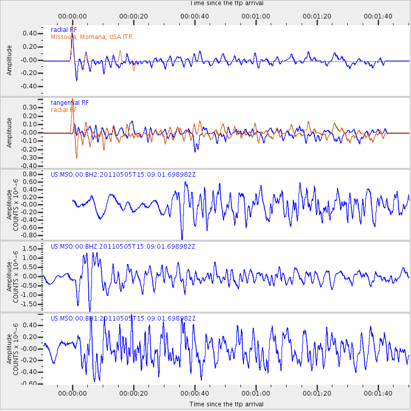
MSO Missoula, Montana, USA - Earthquake Result Viewer
*The percent match for this event was below the threshold and hence no stack was calculated.
| Earthquake location: |
Off East Coast Of Honshu, Japan |
| Earthquake latitude/longitude: |
38.2/144.0 |
| Earthquake time(UTC): |
2011/05/05 (125) 14:58:18 GMT |
| Earthquake Depth: |
11 km |
| Earthquake Magnitude: |
6.2 MB, 5.7 MS, 6.1 MW, 6.1 MW |
| Earthquake Catalog/Contributor: |
WHDF/NEIC |
|
| Network: |
US United States National Seismic Network |
| Station: |
MSO Missoula, Montana, USA |
| Lat/Lon: |
46.83 N/113.94 W |
| Elevation: |
1264 m |
|
| Distance: |
70.4 deg |
| Az: |
45.45 deg |
| Baz: |
305.109 deg |
| Ray Param: |
$rayparam |
*The percent match for this event was below the threshold and hence was not used in the summary stack. |
|
| Radial Match: |
74.90534 % |
| Radial Bump: |
400 |
| Transverse Match: |
71.34383 % |
| Transverse Bump: |
400 |
| SOD ConfigId: |
558545 |
| Insert Time: |
2013-09-18 17:27:47.376 +0000 |
| GWidth: |
2.5 |
| Max Bumps: |
400 |
| Tol: |
0.001 |
|
Signal To Noise
| Channel | StoN | STA | LTA |
| US:MSO:00:BHZ:20110505T15:09:01.698982Z | 4.495105 | 7.3528145E-7 | 1.6357382E-7 |
| US:MSO:00:BH1:20110505T15:09:01.698982Z | 1.7434001 | 1.833683E-7 | 1.0517856E-7 |
| US:MSO:00:BH2:20110505T15:09:01.698982Z | 1.5565289 | 2.2839774E-7 | 1.467353E-7 |
| Arrivals |
| Ps | |
| PpPs | |
| PsPs/PpSs | |


