You are here: Home > Network List > IU - Global Seismograph Network (GSN - IRIS/USGS) Stations List
> Station OTAV Otavalo, Ecuador > Earthquake Result Viewer
OTAV Otavalo, Ecuador - Earthquake Result Viewer
| Earthquake location: |
Alaska Peninsula |
| Earthquake latitude/longitude: |
55.0/-160.7 |
| Earthquake time(UTC): |
2011/05/05 (125) 16:57:36 GMT |
| Earthquake Depth: |
36 km |
| Earthquake Magnitude: |
5.8 MW, 5.8 MW, 6.1 MB |
| Earthquake Catalog/Contributor: |
NEIC PDE/NEIC PDE-M |
|
| Network: |
IU Global Seismograph Network (GSN - IRIS/USGS) |
| Station: |
OTAV Otavalo, Ecuador |
| Lat/Lon: |
0.24 N/78.45 W |
| Elevation: |
3510 m |
|
| Distance: |
85.3 deg |
| Az: |
96.224 deg |
| Baz: |
325.075 deg |
| Ray Param: |
0.044781227 |
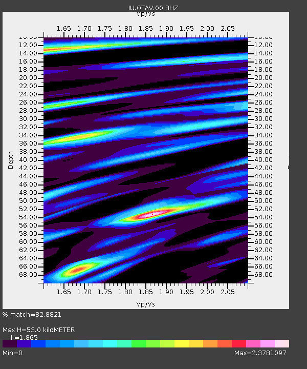
| Estimated Moho Depth: |
53.0 km |
| Estimated Crust Vp/Vs: |
1.87 |
| Assumed Crust Vp: |
6.472 km/s |
| Estimated Crust Vs: |
3.47 km/s |
| Estimated Crust Poisson's Ratio: |
0.30 |
|
| Radial Match: |
82.8821 % |
| Radial Bump: |
400 |
| Transverse Match: |
74.396965 % |
| Transverse Bump: |
400 |
| SOD ConfigId: |
558545 |
| Insert Time: |
2013-09-18 17:31:28.931 +0000 |
| GWidth: |
2.5 |
| Max Bumps: |
400 |
| Tol: |
0.001 |
|
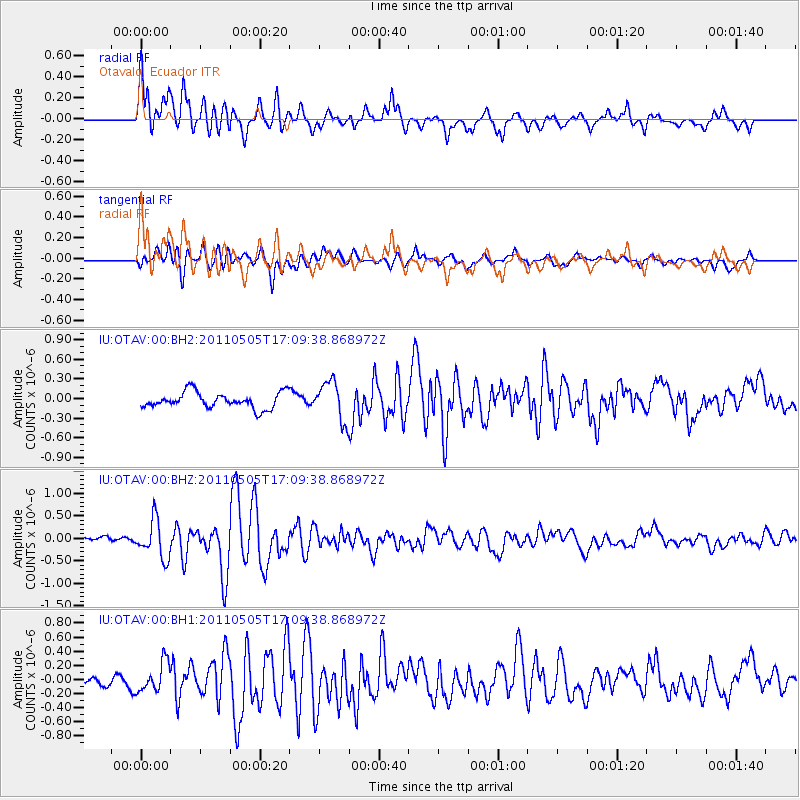
Signal To Noise
| Channel | StoN | STA | LTA |
| IU:OTAV:00:BHZ:20110505T17:09:38.868972Z | 4.7991962 | 4.2708382E-7 | 8.8990696E-8 |
| IU:OTAV:00:BH1:20110505T17:09:38.868972Z | 2.136838 | 2.1318007E-7 | 9.9764264E-8 |
| IU:OTAV:00:BH2:20110505T17:09:38.868972Z | 2.4294782 | 2.948287E-7 | 1.2135476E-7 |
| Arrivals |
| Ps | 7.2 SECOND |
| PpPs | 23 SECOND |
| PsPs/PpSs | 30 SECOND |


