You are here: Home > Network List > US - United States National Seismic Network Stations List
> Station EGMT Eagleton, Montana, USA > Earthquake Result Viewer
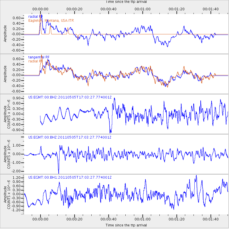
EGMT Eagleton, Montana, USA - Earthquake Result Viewer
*The percent match for this event was below the threshold and hence no stack was calculated.
| Earthquake location: |
Alaska Peninsula |
| Earthquake latitude/longitude: |
55.0/-160.7 |
| Earthquake time(UTC): |
2011/05/05 (125) 16:57:36 GMT |
| Earthquake Depth: |
36 km |
| Earthquake Magnitude: |
5.8 MW, 5.8 MW, 6.1 MB |
| Earthquake Catalog/Contributor: |
NEIC PDE/NEIC PDE-M |
|
| Network: |
US United States National Seismic Network |
| Station: |
EGMT Eagleton, Montana, USA |
| Lat/Lon: |
48.02 N/109.75 W |
| Elevation: |
1055 m |
|
| Distance: |
31.8 deg |
| Az: |
81.169 deg |
| Baz: |
302.037 deg |
| Ray Param: |
$rayparam |
*The percent match for this event was below the threshold and hence was not used in the summary stack. |
|
| Radial Match: |
50.066563 % |
| Radial Bump: |
400 |
| Transverse Match: |
43.756863 % |
| Transverse Bump: |
400 |
| SOD ConfigId: |
558545 |
| Insert Time: |
2013-09-18 17:32:40.221 +0000 |
| GWidth: |
2.5 |
| Max Bumps: |
400 |
| Tol: |
0.001 |
|
Signal To Noise
| Channel | StoN | STA | LTA |
| US:EGMT:00:BHZ:20110505T17:03:27.774001Z | 2.804135 | 3.6039538E-7 | 1.2852283E-7 |
| US:EGMT:00:BH1:20110505T17:03:27.774001Z | 1.1817648 | 8.655251E-7 | 7.3240045E-7 |
| US:EGMT:00:BH2:20110505T17:03:27.774001Z | 1.0198141 | 2.4404997E-7 | 2.393083E-7 |
| Arrivals |
| Ps | |
| PpPs | |
| PsPs/PpSs | |


