You are here: Home > Network List > IU - Global Seismograph Network (GSN - IRIS/USGS) Stations List
> Station HNR Honiara, Solomon Islands > Earthquake Result Viewer
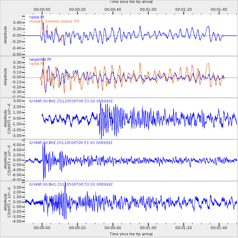
HNR Honiara, Solomon Islands - Earthquake Result Viewer
*The percent match for this event was below the threshold and hence no stack was calculated.
| Earthquake location: |
Minahassa Peninsula, Sulawesi |
| Earthquake latitude/longitude: |
-0.1/122.9 |
| Earthquake time(UTC): |
2011/05/06 (126) 06:46:23 GMT |
| Earthquake Depth: |
82 km |
| Earthquake Magnitude: |
5.8 MB, 5.5 MW, 5.5 MW |
| Earthquake Catalog/Contributor: |
WHDF/NEIC |
|
| Network: |
IU Global Seismograph Network (GSN - IRIS/USGS) |
| Station: |
HNR Honiara, Solomon Islands |
| Lat/Lon: |
9.44 S/159.95 E |
| Elevation: |
100 m |
|
| Distance: |
38.0 deg |
| Az: |
105.264 deg |
| Baz: |
282.099 deg |
| Ray Param: |
$rayparam |
*The percent match for this event was below the threshold and hence was not used in the summary stack. |
|
| Radial Match: |
59.364136 % |
| Radial Bump: |
400 |
| Transverse Match: |
71.55952 % |
| Transverse Bump: |
400 |
| SOD ConfigId: |
558545 |
| Insert Time: |
2013-09-18 17:36:23.963 +0000 |
| GWidth: |
2.5 |
| Max Bumps: |
400 |
| Tol: |
0.001 |
|
Signal To Noise
| Channel | StoN | STA | LTA |
| IU:HNR:00:BHZ:20110506T06:53:03.068999Z | 10.136242 | 3.2061864E-6 | 3.1630918E-7 |
| IU:HNR:00:BH1:20110506T06:53:03.068999Z | 2.3832262 | 8.801492E-7 | 3.6931E-7 |
| IU:HNR:00:BH2:20110506T06:53:03.068999Z | 2.9468534 | 1.317227E-6 | 4.469944E-7 |
| Arrivals |
| Ps | |
| PpPs | |
| PsPs/PpSs | |


