You are here: Home > Network List > US - United States National Seismic Network Stations List
> Station AMTX Amarillo, Texas, USA > Earthquake Result Viewer
AMTX Amarillo, Texas, USA - Earthquake Result Viewer
*The percent match for this event was below the threshold and hence no stack was calculated.
| Earthquake location: |
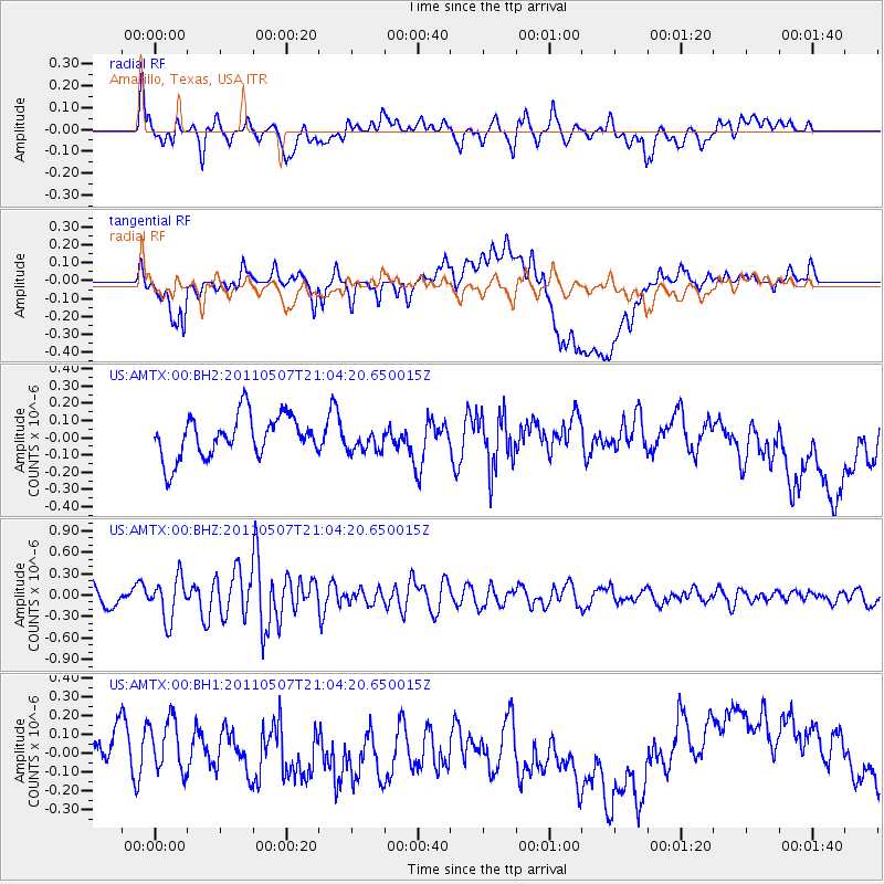
Near East Coast Of Honshu, Japan |
| Earthquake latitude/longitude: |
40.2/142.2 |
| Earthquake time(UTC): |
2011/05/07 (127) 20:52:20 GMT |
| Earthquake Depth: |
35 km |
| Earthquake Magnitude: |
5.5 MB, 5.2 MS, 5.7 MW, 5.7 MW |
| Earthquake Catalog/Contributor: |
WHDF/NEIC |
|
| Network: |
US United States National Seismic Network |
| Station: |
AMTX Amarillo, Texas, USA |
| Lat/Lon: |
34.53 N/101.41 W |
| Elevation: |
1010 m |
|
| Distance: |
85.3 deg |
| Az: |
47.933 deg |
| Baz: |
316.503 deg |
| Ray Param: |
$rayparam |
*The percent match for this event was below the threshold and hence was not used in the summary stack. |
|
| Radial Match: |
51.801434 % |
| Radial Bump: |
400 |
| Transverse Match: |
28.422342 % |
| Transverse Bump: |
400 |
| SOD ConfigId: |
558545 |
| Insert Time: |
2013-09-18 17:39:05.838 +0000 |
| GWidth: |
2.5 |
| Max Bumps: |
400 |
| Tol: |
0.001 |
|
Signal To Noise
| Channel | StoN | STA | LTA |
| US:AMTX:00:BHZ:20110507T21:04:20.650015Z | 2.5358276 | 2.9270004E-7 | 1.1542584E-7 |
| US:AMTX:00:BH1:20110507T21:04:20.650015Z | 1.1515625 | 1.552817E-7 | 1.3484436E-7 |
| US:AMTX:00:BH2:20110507T21:04:20.650015Z | 0.54708505 | 6.45708E-8 | 1.1802698E-7 |
| Arrivals |
| Ps | |
| PpPs | |
| PsPs/PpSs | |


