You are here: Home > Network List > US - United States National Seismic Network Stations List
> Station BOZ Bozeman, Montana, USA > Earthquake Result Viewer
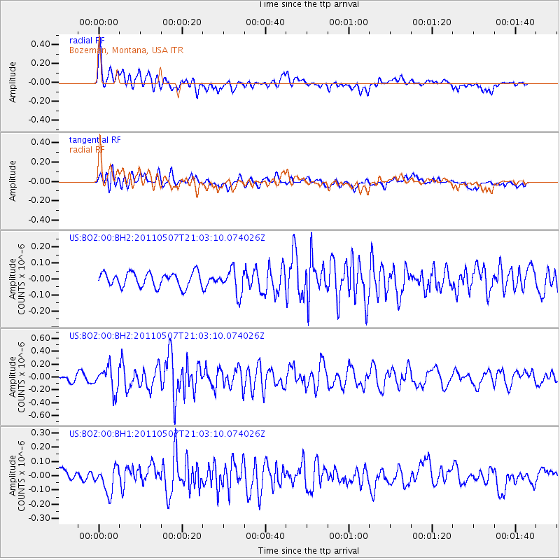
BOZ Bozeman, Montana, USA - Earthquake Result Viewer
*The percent match for this event was below the threshold and hence no stack was calculated.
| Earthquake location: |
Near East Coast Of Honshu, Japan |
| Earthquake latitude/longitude: |
40.2/142.2 |
| Earthquake time(UTC): |
2011/05/07 (127) 20:52:20 GMT |
| Earthquake Depth: |
35 km |
| Earthquake Magnitude: |
5.5 MB, 5.2 MS, 5.7 MW, 5.7 MW |
| Earthquake Catalog/Contributor: |
WHDF/NEIC |
|
| Network: |
US United States National Seismic Network |
| Station: |
BOZ Bozeman, Montana, USA |
| Lat/Lon: |
45.65 N/111.63 W |
| Elevation: |
1589 m |
|
| Distance: |
72.0 deg |
| Az: |
45.125 deg |
| Baz: |
309.347 deg |
| Ray Param: |
$rayparam |
*The percent match for this event was below the threshold and hence was not used in the summary stack. |
|
| Radial Match: |
67.35914 % |
| Radial Bump: |
400 |
| Transverse Match: |
55.484562 % |
| Transverse Bump: |
400 |
| SOD ConfigId: |
558545 |
| Insert Time: |
2013-09-18 17:39:10.150 +0000 |
| GWidth: |
2.5 |
| Max Bumps: |
400 |
| Tol: |
0.001 |
|
Signal To Noise
| Channel | StoN | STA | LTA |
| US:BOZ:00:BHZ:20110507T21:03:10.074026Z | 3.6622345 | 1.8733779E-7 | 5.1153954E-8 |
| US:BOZ:00:BH1:20110507T21:03:10.074026Z | 1.6085136 | 9.0581615E-8 | 5.6313866E-8 |
| US:BOZ:00:BH2:20110507T21:03:10.074026Z | 1.7986515 | 7.957404E-8 | 4.4240945E-8 |
| Arrivals |
| Ps | |
| PpPs | |
| PsPs/PpSs | |


