You are here: Home > Network List > IU - Global Seismograph Network (GSN - IRIS/USGS) Stations List
> Station MAJO Matsushiro, Japan > Earthquake Result Viewer
MAJO Matsushiro, Japan - Earthquake Result Viewer
*The percent match for this event was below the threshold and hence no stack was calculated.
| Earthquake location: |
West Of Macquarie Island |
| Earthquake latitude/longitude: |
-56.7/147.4 |
| Earthquake time(UTC): |
2011/05/09 (129) 18:54:43 GMT |
| Earthquake Depth: |
9.0 km |
| Earthquake Magnitude: |
5.7 MB, 5.7 MS, 6.1 MW, 5.9 MW |
| Earthquake Catalog/Contributor: |
WHDF/NEIC |
|
| Network: |
IU Global Seismograph Network (GSN - IRIS/USGS) |
| Station: |
MAJO Matsushiro, Japan |
| Lat/Lon: |
36.55 N/138.20 E |
| Elevation: |
405 m |
|
| Distance: |
93.2 deg |
| Az: |
352.586 deg |
| Baz: |
174.922 deg |
| Ray Param: |
$rayparam |
*The percent match for this event was below the threshold and hence was not used in the summary stack. |
|
| Radial Match: |
49.015945 % |
| Radial Bump: |
400 |
| Transverse Match: |
51.379505 % |
| Transverse Bump: |
393 |
| SOD ConfigId: |
558545 |
| Insert Time: |
2013-09-18 17:41:39.832 +0000 |
| GWidth: |
2.5 |
| Max Bumps: |
400 |
| Tol: |
0.001 |
|
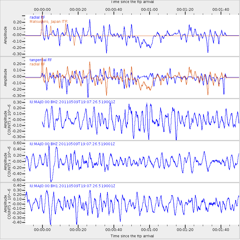
Signal To Noise
| Channel | StoN | STA | LTA |
| IU:MAJO:00:BHZ:20110509T19:07:26.519001Z | 2.0207033 | 2.5531108E-7 | 1.2634764E-7 |
| IU:MAJO:00:BH1:20110509T19:07:26.519001Z | 1.3422563 | 2.2573305E-7 | 1.6817432E-7 |
| IU:MAJO:00:BH2:20110509T19:07:26.519001Z | 1.1509409 | 1.18548094E-7 | 1.0300103E-7 |
| Arrivals |
| Ps | |
| PpPs | |
| PsPs/PpSs | |


