You are here: Home > Network List > IU - Global Seismograph Network (GSN - IRIS/USGS) Stations List
> Station HNR Honiara, Solomon Islands > Earthquake Result Viewer
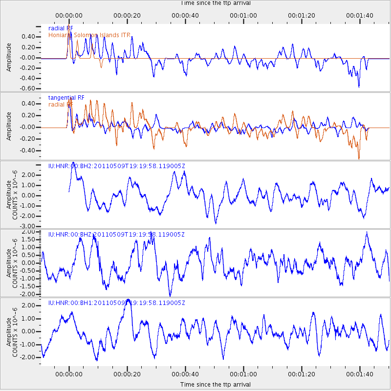
HNR Honiara, Solomon Islands - Earthquake Result Viewer
*The percent match for this event was below the threshold and hence no stack was calculated.
| Earthquake location: |
Mindanao, Philippines |
| Earthquake latitude/longitude: |
5.3/126.4 |
| Earthquake time(UTC): |
2011/05/09 (129) 19:13:25 GMT |
| Earthquake Depth: |
29 km |
| Earthquake Magnitude: |
5.5 MB, 5.5 MS, 5.7 MW |
| Earthquake Catalog/Contributor: |
WHDF/NEIC |
|
| Network: |
IU Global Seismograph Network (GSN - IRIS/USGS) |
| Station: |
HNR Honiara, Solomon Islands |
| Lat/Lon: |
9.44 S/159.95 E |
| Elevation: |
100 m |
|
| Distance: |
36.5 deg |
| Az: |
113.616 deg |
| Baz: |
292.38 deg |
| Ray Param: |
$rayparam |
*The percent match for this event was below the threshold and hence was not used in the summary stack. |
|
| Radial Match: |
70.10648 % |
| Radial Bump: |
400 |
| Transverse Match: |
71.0717 % |
| Transverse Bump: |
400 |
| SOD ConfigId: |
558545 |
| Insert Time: |
2013-09-18 17:42:36.336 +0000 |
| GWidth: |
2.5 |
| Max Bumps: |
400 |
| Tol: |
0.001 |
|
Signal To Noise
| Channel | StoN | STA | LTA |
| IU:HNR:00:BHZ:20110509T19:19:58.119005Z | 1.1059366 | 9.529415E-7 | 8.6166006E-7 |
| IU:HNR:00:BH1:20110509T19:19:58.119005Z | 0.9393602 | 1.0824053E-6 | 1.1522793E-6 |
| IU:HNR:00:BH2:20110509T19:19:58.119005Z | 1.2107639 | 1.456543E-6 | 1.2029951E-6 |
| Arrivals |
| Ps | |
| PpPs | |
| PsPs/PpSs | |


