You are here: Home > Network List > II - Global Seismograph Network (GSN - IRIS/IDA) Stations List
> Station WRAB Tennant Creek, NT, Australia > Earthquake Result Viewer
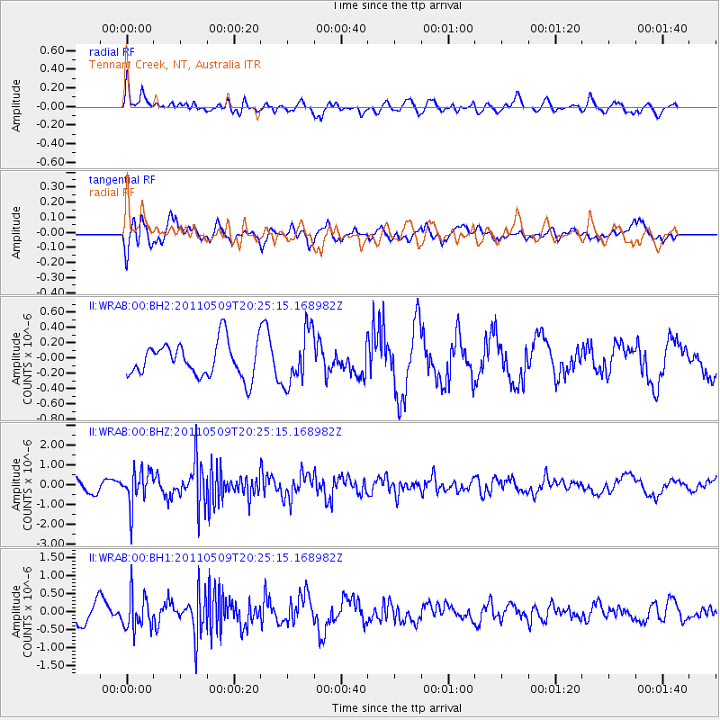
WRAB Tennant Creek, NT, Australia - Earthquake Result Viewer
*The percent match for this event was below the threshold and hence no stack was calculated.
| Earthquake location: |
Off East Coast Of Honshu, Japan |
| Earthquake latitude/longitude: |
37.7/143.5 |
| Earthquake time(UTC): |
2011/05/09 (129) 20:15:53 GMT |
| Earthquake Depth: |
10 km |
| Earthquake Magnitude: |
6.0 MB, 5.2 MS, 5.6 MW |
| Earthquake Catalog/Contributor: |
WHDF/NEIC |
|
| Network: |
II Global Seismograph Network (GSN - IRIS/IDA) |
| Station: |
WRAB Tennant Creek, NT, Australia |
| Lat/Lon: |
19.93 S/134.36 E |
| Elevation: |
366 m |
|
| Distance: |
58.0 deg |
| Az: |
190.19 deg |
| Baz: |
8.574 deg |
| Ray Param: |
$rayparam |
*The percent match for this event was below the threshold and hence was not used in the summary stack. |
|
| Radial Match: |
49.372932 % |
| Radial Bump: |
400 |
| Transverse Match: |
50.51208 % |
| Transverse Bump: |
400 |
| SOD ConfigId: |
558545 |
| Insert Time: |
2013-09-18 17:43:49.964 +0000 |
| GWidth: |
2.5 |
| Max Bumps: |
400 |
| Tol: |
0.001 |
|
Signal To Noise
| Channel | StoN | STA | LTA |
| II:WRAB:00:BHZ:20110509T20:25:15.168982Z | 3.2702334 | 8.863623E-7 | 2.7103945E-7 |
| II:WRAB:00:BH1:20110509T20:25:15.168982Z | 1.9410988 | 4.7310172E-7 | 2.437288E-7 |
| II:WRAB:00:BH2:20110509T20:25:15.168982Z | 1.5844345 | 3.5347233E-7 | 2.2309054E-7 |
| Arrivals |
| Ps | |
| PpPs | |
| PsPs/PpSs | |


