You are here: Home > Network List > US - United States National Seismic Network Stations List
> Station NEW Newport, Washington, USA > Earthquake Result Viewer
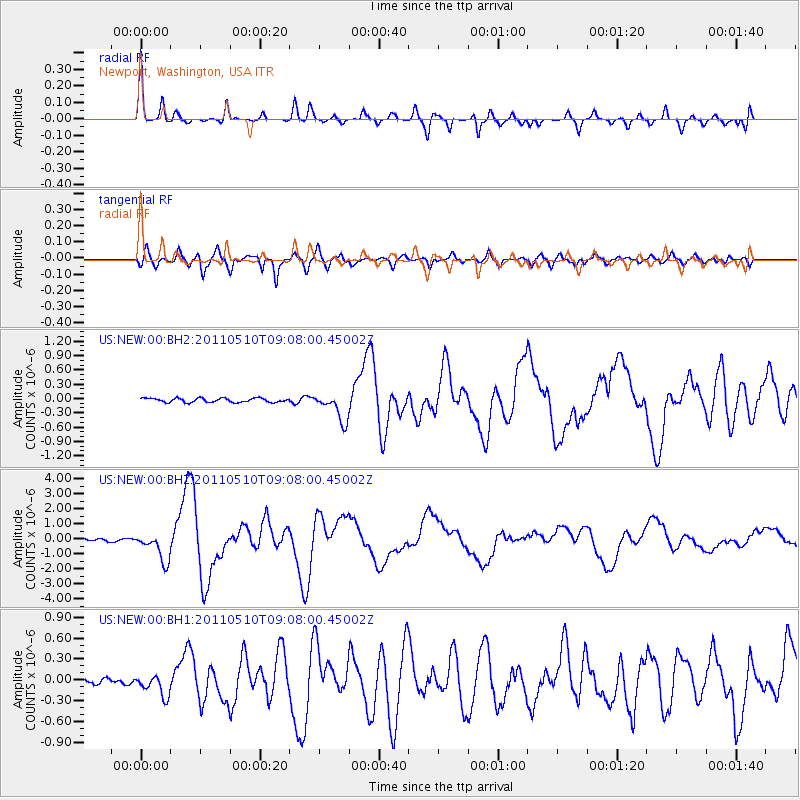
NEW Newport, Washington, USA - Earthquake Result Viewer

| Earthquake location: |
Loyalty Islands |
| Earthquake latitude/longitude: |
-20.2/168.2 |
| Earthquake time(UTC): |
2011/05/10 (130) 08:55:08 GMT |
| Earthquake Depth: |
11 km |
| Earthquake Magnitude: |
6.4 MB, 6.8 MS, 6.9 MW, 6.8 MW |
| Earthquake Catalog/Contributor: |
WHDF/NEIC |
|
| Network: |
US United States National Seismic Network |
| Station: |
NEW Newport, Washington, USA |
| Lat/Lon: |
48.26 N/117.12 W |
| Elevation: |
760 m |
|
| Distance: |
95.2 deg |
| Az: |
40.315 deg |
| Baz: |
245.392 deg |
| Ray Param: |
0.040856622 |
| Estimated Moho Depth: |
37.0 km |
| Estimated Crust Vp/Vs: |
1.61 |
| Assumed Crust Vp: |
6.571 km/s |
| Estimated Crust Vs: |
4.088 km/s |
| Estimated Crust Poisson's Ratio: |
0.18 |
|
| Radial Match: |
93.38911 % |
| Radial Bump: |
318 |
| Transverse Match: |
91.711586 % |
| Transverse Bump: |
400 |
| SOD ConfigId: |
558545 |
| Insert Time: |
2013-09-18 17:48:30.326 +0000 |
| GWidth: |
2.5 |
| Max Bumps: |
400 |
| Tol: |
0.001 |
|
Signal To Noise
| Channel | StoN | STA | LTA |
| US:NEW:00:BHZ:20110510T09:08:00.45002Z | 10.939038 | 9.4426457E-7 | 8.632062E-8 |
| US:NEW:00:BH1:20110510T09:08:00.45002Z | 2.4286084 | 1.5150067E-7 | 6.238168E-8 |
| US:NEW:00:BH2:20110510T09:08:00.45002Z | 7.032389 | 2.9694542E-7 | 4.2225395E-8 |
| Arrivals |
| Ps | 3.5 SECOND |
| PpPs | 14 SECOND |
| PsPs/PpSs | 18 SECOND |


