You are here: Home > Network List > US - United States National Seismic Network Stations List
> Station WVOR Wild Horse Valley, Oregon, USA > Earthquake Result Viewer
WVOR Wild Horse Valley, Oregon, USA - Earthquake Result Viewer
| Earthquake location: |
Loyalty Islands |
| Earthquake latitude/longitude: |
-20.2/168.2 |
| Earthquake time(UTC): |
2011/05/10 (130) 08:55:08 GMT |
| Earthquake Depth: |
11 km |
| Earthquake Magnitude: |
6.4 MB, 6.8 MS, 6.9 MW, 6.8 MW |
| Earthquake Catalog/Contributor: |
WHDF/NEIC |
|
| Network: |
US United States National Seismic Network |
| Station: |
WVOR Wild Horse Valley, Oregon, USA |
| Lat/Lon: |
42.43 N/118.64 W |
| Elevation: |
1344 m |
|
| Distance: |
91.7 deg |
| Az: |
45.136 deg |
| Baz: |
244.027 deg |
| Ray Param: |
0.041570265 |
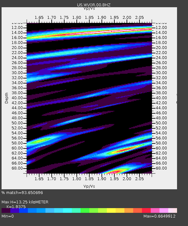
| Estimated Moho Depth: |
13.25 km |
| Estimated Crust Vp/Vs: |
1.94 |
| Assumed Crust Vp: |
6.279 km/s |
| Estimated Crust Vs: |
3.241 km/s |
| Estimated Crust Poisson's Ratio: |
0.32 |
|
| Radial Match: |
93.650696 % |
| Radial Bump: |
400 |
| Transverse Match: |
89.986725 % |
| Transverse Bump: |
400 |
| SOD ConfigId: |
558545 |
| Insert Time: |
2013-09-18 17:48:44.344 +0000 |
| GWidth: |
2.5 |
| Max Bumps: |
400 |
| Tol: |
0.001 |
|
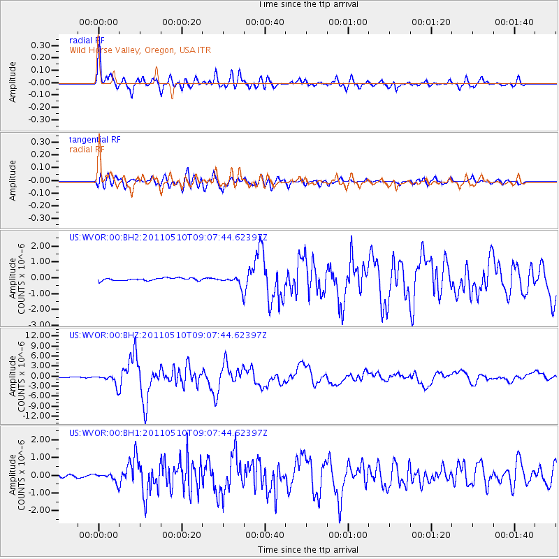
Signal To Noise
| Channel | StoN | STA | LTA |
| US:WVOR:00:BHZ:20110510T09:07:44.62397Z | 20.64229 | 1.6708952E-6 | 8.094525E-8 |
| US:WVOR:00:BH1:20110510T09:07:44.62397Z | 3.2233 | 2.6543987E-7 | 8.235035E-8 |
| US:WVOR:00:BH2:20110510T09:07:44.62397Z | 4.336586 | 3.5084022E-7 | 8.0902396E-8 |
| Arrivals |
| Ps | 2.0 SECOND |
| PpPs | 6.1 SECOND |
| PsPs/PpSs | 8.1 SECOND |


