You are here: Home > Network List > US - United States National Seismic Network Stations List
> Station AMTX Amarillo, Texas, USA > Earthquake Result Viewer
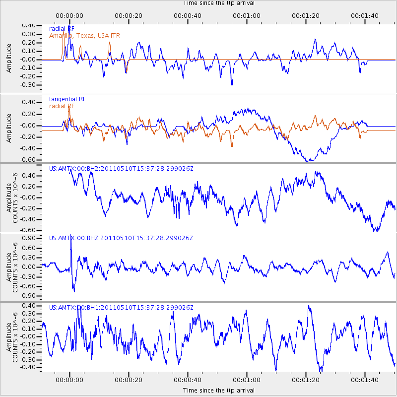
AMTX Amarillo, Texas, USA - Earthquake Result Viewer
*The percent match for this event was below the threshold and hence no stack was calculated.
| Earthquake location: |
E. Russia-N.E. China Border Reg. |
| Earthquake latitude/longitude: |
43.3/130.9 |
| Earthquake time(UTC): |
2011/05/10 (130) 15:26:04 GMT |
| Earthquake Depth: |
545 km |
| Earthquake Magnitude: |
5.7 MW |
| Earthquake Catalog/Contributor: |
NEIC PDE/NEIC PDE-M |
|
| Network: |
US United States National Seismic Network |
| Station: |
AMTX Amarillo, Texas, USA |
| Lat/Lon: |
34.53 N/101.41 W |
| Elevation: |
1010 m |
|
| Distance: |
89.0 deg |
| Az: |
40.824 deg |
| Baz: |
324.678 deg |
| Ray Param: |
$rayparam |
*The percent match for this event was below the threshold and hence was not used in the summary stack. |
|
| Radial Match: |
41.378677 % |
| Radial Bump: |
400 |
| Transverse Match: |
33.82284 % |
| Transverse Bump: |
400 |
| SOD ConfigId: |
558545 |
| Insert Time: |
2013-09-18 17:55:10.632 +0000 |
| GWidth: |
2.5 |
| Max Bumps: |
400 |
| Tol: |
0.001 |
|
Signal To Noise
| Channel | StoN | STA | LTA |
| US:AMTX:00:BHZ:20110510T15:37:28.299026Z | 2.3435826 | 3.81061E-7 | 1.6259764E-7 |
| US:AMTX:00:BH1:20110510T15:37:28.299026Z | 0.9286566 | 1.679328E-7 | 1.8083412E-7 |
| US:AMTX:00:BH2:20110510T15:37:28.299026Z | 0.69227815 | 1.3874968E-7 | 2.0042476E-7 |
| Arrivals |
| Ps | |
| PpPs | |
| PsPs/PpSs | |


