You are here: Home > Network List > TA - USArray Transportable Network (new EarthScope stations) Stations List
> Station O48A Farmland, IN, USA > Earthquake Result Viewer
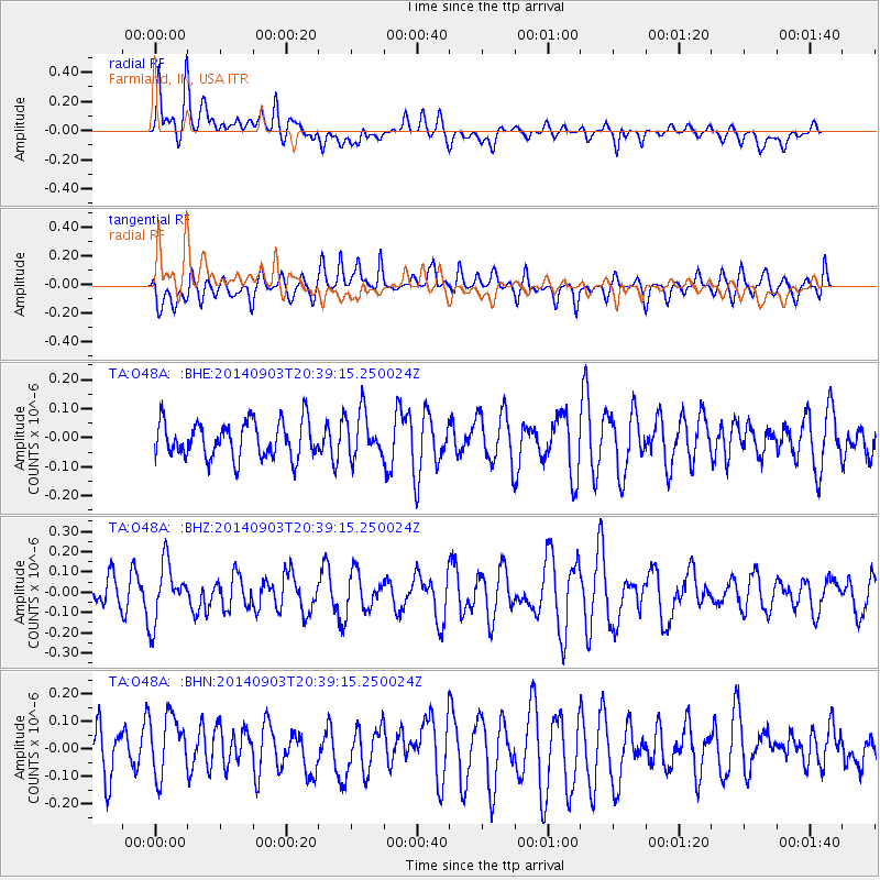
O48A Farmland, IN, USA - Earthquake Result Viewer
*The percent match for this event was below the threshold and hence no stack was calculated.
| Earthquake location: |
Easter Island Region |
| Earthquake latitude/longitude: |
-26.6/-115.0 |
| Earthquake time(UTC): |
2014/09/03 (246) 20:28:22 GMT |
| Earthquake Depth: |
10 km |
| Earthquake Magnitude: |
5.5 MW |
| Earthquake Catalog/Contributor: |
ISC/ISC |
|
| Network: |
TA USArray Transportable Network (new EarthScope stations) |
| Station: |
O48A Farmland, IN, USA |
| Lat/Lon: |
40.26 N/85.16 W |
| Elevation: |
300 m |
|
| Distance: |
72.1 deg |
| Az: |
23.585 deg |
| Baz: |
207.916 deg |
| Ray Param: |
$rayparam |
*The percent match for this event was below the threshold and hence was not used in the summary stack. |
|
| Radial Match: |
56.273518 % |
| Radial Bump: |
400 |
| Transverse Match: |
46.239517 % |
| Transverse Bump: |
400 |
| SOD ConfigId: |
3390531 |
| Insert Time: |
2019-04-13 20:02:42.649 +0000 |
| GWidth: |
2.5 |
| Max Bumps: |
400 |
| Tol: |
0.001 |
|
Signal To Noise
| Channel | StoN | STA | LTA |
| TA:O48A: :BHZ:20140903T20:39:15.250024Z | 1.5308045 | 1.4351113E-7 | 9.3748824E-8 |
| TA:O48A: :BHN:20140903T20:39:15.250024Z | 1.4298959 | 1.2692786E-7 | 8.87672E-8 |
| TA:O48A: :BHE:20140903T20:39:15.250024Z | 1.2424123 | 7.664092E-8 | 6.168718E-8 |
| Arrivals |
| Ps | |
| PpPs | |
| PsPs/PpSs | |


