You are here: Home > Network List > US - United States National Seismic Network Stations List
> Station WUAZ Wupatki, Arizona, USA > Earthquake Result Viewer
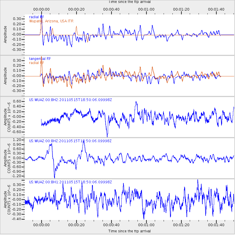
WUAZ Wupatki, Arizona, USA - Earthquake Result Viewer
*The percent match for this event was below the threshold and hence no stack was calculated.
| Earthquake location: |
Solomon Islands |
| Earthquake latitude/longitude: |
-6.1/154.4 |
| Earthquake time(UTC): |
2011/05/15 (135) 18:37:10 GMT |
| Earthquake Depth: |
40 km |
| Earthquake Magnitude: |
6.3 MB, 6.2 MS, 6.5 MW, 6.5 MW |
| Earthquake Catalog/Contributor: |
WHDF/NEIC |
|
| Network: |
US United States National Seismic Network |
| Station: |
WUAZ Wupatki, Arizona, USA |
| Lat/Lon: |
35.52 N/111.37 W |
| Elevation: |
1592 m |
|
| Distance: |
96.9 deg |
| Az: |
55.042 deg |
| Baz: |
267.464 deg |
| Ray Param: |
$rayparam |
*The percent match for this event was below the threshold and hence was not used in the summary stack. |
|
| Radial Match: |
60.444065 % |
| Radial Bump: |
400 |
| Transverse Match: |
72.66441 % |
| Transverse Bump: |
400 |
| SOD ConfigId: |
558545 |
| Insert Time: |
2013-09-18 18:23:19.225 +0000 |
| GWidth: |
2.5 |
| Max Bumps: |
400 |
| Tol: |
0.001 |
|
Signal To Noise
| Channel | StoN | STA | LTA |
| US:WUAZ:00:BHZ:20110515T18:50:06.09998Z | 4.789831 | 3.550988E-7 | 7.413597E-8 |
| US:WUAZ:00:BH1:20110515T18:50:06.09998Z | 1.335115 | 8.4466976E-8 | 6.3265695E-8 |
| US:WUAZ:00:BH2:20110515T18:50:06.09998Z | 0.7749201 | 1.3214782E-7 | 1.705309E-7 |
| Arrivals |
| Ps | |
| PpPs | |
| PsPs/PpSs | |


